IMAGES TAKEN NEAR TO
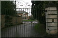
Thorold Way, LINCOLN, LN5 9GJ
Introduction
This page details the photographs taken nearby to Thorold Way, LN5 9GJ by members of the Geograph project.
The Geograph project started in 2005 with the aim of publishing, organising and preserving representative images for every square kilometre of Great Britain, Ireland and the Isle of Man.

There are currently over 7.5m images from over14,400 individuals and you can help contribute to the project by visiting https://www.geograph.org.uk
Image Map
Images are licensed for reuse under creativecommons.org/licenses/by-sa/2.0
Notes
- Clicking on the map will re-center to the selected point.
- The higher the marker number, the further away the image location is from the centre of the postcode.
Image Listing (38 Images Found)
Images are licensed for reuse under creativecommons.org/licenses/by-sa/2.0
Image
Details
Distance
1
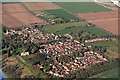
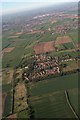
Harmston and its Crescent: aerial 2017
I have placed this picture in this square to focus on the crescent-shaped building. For more Harmston see Image
To look at it from the ground see Image I was surprised to see that it is new, and not a historic building!
Image: © Chris
Taken: 25 Mar 2017
0.03 miles
2
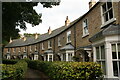
Crescent in Harmston
Intrigued when I spotted this from the air in Image, I had to see it from the ground. To my surprise it is not a historic building but recently built.
Image: © Chris
Taken: 17 Oct 2020
0.04 miles
3
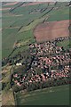
Harmston: aerial 2017
Though most of the village is in this square, my eye is always drawn by the crescent-shaped building, in the next square, for which see also Image
Village is on "the Cliff" - picture shows the slope down on to the plain below.
Image: © Chris
Taken: 25 Mar 2017
0.05 miles
4
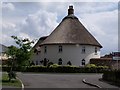
Thatched house on Harmston Park Avenue
Image: © J.Hannan-Briggs
Taken: 10 Jul 2011
0.08 miles
6
Harmston and the Cliff to Lincoln
Image: © Chris
Taken: 25 Mar 2017
0.20 miles
7
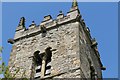
Gargoyles on Tower, All Saints' church, Harmston
Image: © J.Hannan-Briggs
Taken: 16 May 2012
0.21 miles
8
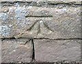
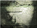
Ordnance Survey Cut Mark
This OS cut mark can be found on the south face of All Saints Church. It marks a point 79.495m above mean sea level.
Image: © Adrian Dust
Taken: 21 Jul 2017
0.21 miles
9
Harmston, All Saints' Church, cut bench mark
The south face of the church tower - see Image - carries a good condition cut bench mark low down. The mark was levelled at 79.4949m above Newlyn datum and verified in 1966. See http://www.bench-marks.org.uk/bm34632 for Bench Marks database record.
Image: © Brian Westlake
Taken: 10 Jun 2010
0.21 miles
10
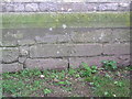
Ordnance Survey Cut Mark
This mark can be found on the wall of All Saints Church.
For more detail see : http://www.bench-marks.org.uk/bm34632
Image: © Peter Wood
Taken: 22 Aug 2012
0.21 miles