IMAGES TAKEN NEAR TO
London Road, LINCOLN, LN4 2JW
Introduction
This page details the photographs taken nearby to London Road, LN4 2JW by members of the Geograph project.
The Geograph project started in 2005 with the aim of publishing, organising and preserving representative images for every square kilometre of Great Britain, Ireland and the Isle of Man.

There are currently over 7.5m images from over14,400 individuals and you can help contribute to the project by visiting https://www.geograph.org.uk
Image Map
Images are licensed for reuse under creativecommons.org/licenses/by-sa/2.0
Notes
- Clicking on the map will re-center to the selected point.
- The higher the marker number, the further away the image location is from the centre of the postcode.
Image Listing (26 Images Found)
Images are licensed for reuse under creativecommons.org/licenses/by-sa/2.0
Image
Details
Distance
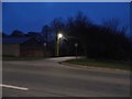
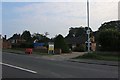
3
London Road at the junction of Stanley Crescent
Image: © David Howard
Taken: 13 Jan 2018
0.12 miles
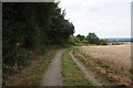
5
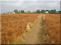
Public footpath north of Bracebridge Heath
View north along a well-defined path leading to houses on Coningsby Crescent. The crop here is linseed, which looks ready for harvest.
Image: © Trevor Rickard
Taken: 5 Aug 2012
0.14 miles
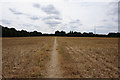
6
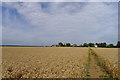
The Viking Way heading towards the A15 north of Bracebridge Heath
Wheat in the field this year; linseed last year Image
Image: © Tim Heaton
Taken: 23 Aug 2013
0.16 miles
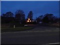
7
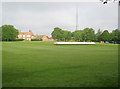
Bracebridge Heath cricket ground
This rather pleasant ground in front of Cross O'Cliff Court is the home of Bracebridge Heath CC.
Image: © Trevor Rickard
Taken: 5 Aug 2012
0.16 miles
10
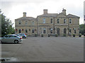
The Homestead
From the car park looking east to the Fayre and Square pub/restaurant building. Originally part of the county lunatic asylum complex built in 1852 (later became St John’s Hospital - see Image ), this grand house was the medical director’s residence. The building was converted into a public house in the late 1990s and is Grade II Listed.
Image: © Trevor Rickard
Taken: 5 Aug 2012
0.18 miles