IMAGES TAKEN NEAR TO
Sea Lane, MABLETHORPE, LN12 2RA
Introduction
This page details the photographs taken nearby to Sea Lane, LN12 2RA by members of the Geograph project.
The Geograph project started in 2005 with the aim of publishing, organising and preserving representative images for every square kilometre of Great Britain, Ireland and the Isle of Man.

There are currently over 7.5m images from over14,400 individuals and you can help contribute to the project by visiting https://www.geograph.org.uk
Image Map
Images are licensed for reuse under creativecommons.org/licenses/by-sa/2.0
Notes
- Clicking on the map will re-center to the selected point.
- The higher the marker number, the further away the image location is from the centre of the postcode.
Image Listing (17 Images Found)
Images are licensed for reuse under creativecommons.org/licenses/by-sa/2.0
Image
Details
Distance
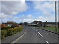
2

School bus
Just setting off after dropping pupils at the stop on the triangle formed by Sea Lane and Huttoft Road. The vehicle is a Dennis Dart (registration mark NBZ 1670) of Grayscroft Coaches, founded in 1924 and operating from Mablethorpe.
Image: © Jonathan Wilkins
Taken: 24 Apr 2014
0.04 miles
3
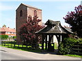
St. Clements Church, Sutton on Sea, Lincolnshire
The lych gate is a war memorial, as it is dedicated to a man who died in World War 1
Image: © John Readman
Taken: 9 May 2006
0.06 miles
4
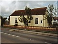
Chapel Cottage, Sea Lane, Sandilands
Situated on the triangle at the start of sea lane/A52 junction, the old Methodist chapel until c.1900, when it was converted to a home. I lived there from 1996 to 2002.
Image: © DAVID BAILEY
Taken: Unknown
0.08 miles
5
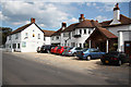
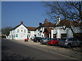
Grange & Links Hotel
Three star hotel on Sea Lane, Sandilands http://www.grangeandlinkshotel.co.uk/
Image: © Richard Croft
Taken: 19 Aug 2011
0.10 miles
6
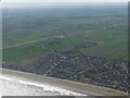
Sandilands to Mablethorpe, across Boy Grift Drain: aerial 2022
Image: © Simon Tomson
Taken: 8 Apr 2022
0.11 miles
7
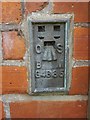
Flush Bracket OSBM G4685: Sandilands, Gatehouse
See http://www.geograph.org.uk/photo/5120934 for a wider view and http://www.bench-marks.org.uk/bm13498 for details.
Image: © Brian Westlake
Taken: 7 Sep 2016
0.12 miles
8

Flush Bracket OSBM G4685: Sandilands, Gatehouse
Flush bracket on the former gatehouse for a railway crossing, long gone. See http://www.geograph.org.uk/photo/5120913 for a close-up and http://www.bench-marks.org.uk/bm13498 for details.
Image: © Brian Westlake
Taken: 7 Sep 2016
0.12 miles
9
The Grange and Links Hotel at Sandilands
Image: © Richard Hoare
Taken: 5 May 2010
0.12 miles
10
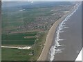
Sandilands and Viking Link cable route: aerial 2022
Looking towards Boy Grift Drain and the Viking Link cable route.
Viking Link is a 1,400 MW HVDC submarine power cable under construction between the United Kingdom and Denmark. See: https://en.wikipedia.org/wiki/Viking_Link
It comes onshore south of Sandilands (alongside Boy Grift Drain) and is to finish at Bicker Fen substation.
See also Image] and Image
Image: © Simon Tomson
Taken: 8 Apr 2022
0.16 miles