IMAGES TAKEN NEAR TO
Kelsey Street, LINCOLN, LN1 1XA
Introduction
This page details the photographs taken nearby to Kelsey Street, LN1 1XA by members of the Geograph project.
The Geograph project started in 2005 with the aim of publishing, organising and preserving representative images for every square kilometre of Great Britain, Ireland and the Isle of Man.

There are currently over 7.5m images from over14,400 individuals and you can help contribute to the project by visiting https://www.geograph.org.uk
Image Map
Images are licensed for reuse under creativecommons.org/licenses/by-sa/2.0
Notes
- Clicking on the map will re-center to the selected point.
- The higher the marker number, the further away the image location is from the centre of the postcode.
Image Listing (1749 Images Found)
Images are licensed for reuse under creativecommons.org/licenses/by-sa/2.0
Image
Details
Distance
1
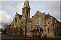
New Life Christian Fellowship
Built in 1876 as Newland Congregational church with the earlier building to the right of 1840, these two buildings are now home to the Lincoln New Life Christian Fellowship http://www.newlifelincoln.org.uk/
Image: © Richard Croft
Taken: 25 Jan 2006
0.01 miles
2
Wigford Way bridge across the River Witham
Image: © Mat Fascione
Taken: 19 Oct 2015
0.02 miles
3
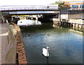
Road Bridge at Brayford Wharf East (2)
This photo shows the Wigford Way road bridge over the River Witham looking west towards Brayford Pool. The wording "WHERE ARE YOU GOING?" has been etched on a metal plate fixed on the bridge whilst a mural has been drawn on the other side below the parapet.
Image: © David Hillas
Taken: 16 Jul 2019
0.02 miles
4
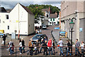
Water Lane
Folks walking along Waterside north and view up Water Lane from Waterside south
Image: © Richard Croft
Taken: 28 Aug 2010
0.02 miles
5
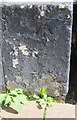
Benchmark on 16 Guildhall Street (Water Lane Face)
Ordnance Survey cut mark benchmark described on the Bench Mark Database at www.bench-mark.org.uk/bm111581
Image: © phil Richards
Taken: 11 Sep 2019
0.02 miles
6
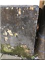
Cut Mark: Lincoln, 16 Guildhall Street
Cut bench mark on the west face at the rear of the building, facing Water Lane. See https://www.geograph.org.uk/photo/6369888 for a wider view and https://www.bench-marks.org.uk/bm111581 for details of the mark.
Image: © Brian Westlake
Taken: 10 Jan 2020
0.02 miles
7
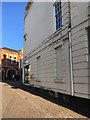
Water Lane side of Red Five bar
There is a cut bench mark on the west face at the rear of the building, facing Water Lane. See https://www.geograph.org.uk/photo/6369884 for a closer view and https://www.bench-marks.org.uk/bm111581 for details of the mark.
Image: © Brian Westlake
Taken: 10 Jan 2020
0.02 miles
8
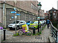
First in last out parking off Water Lane, Lincoln
The notice on the wall says 'Primark Goods Inwards No Parking'. Presumably this no longer applies.
Image: © Humphrey Bolton
Taken: 24 Aug 2021
0.02 miles
9
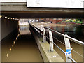
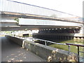
Flooding under Wigford Way
At least from 1888 up to the building of Wigford Way in the early 1970s the road that this footpath replaces was called Brayford Head. The Environment Agency set to work improving water defences around Lincoln after the 2007 floods in order to prevent flooding in the city. Overgrown bushes and shrubs were to be removed from Stamp End and south Bracebridge while it was intended an area of Henley Street was to be flattened out to keep flood defences at the correct height. Bargate Sluice, also in Bracebridge, was to be fully sealed in an effort to maintain flood defences.
Image: © Jo and Steve Turner
Taken: 26 Jun 2007
0.02 miles
10
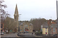
Wigford Way
Looking northwards towards the Alive church.
Image: © Robert Eva
Taken: 15 Jan 2020
0.02 miles