IMAGES TAKEN NEAR TO
Brackenborough, LOUTH, LN11 0NR
Introduction
This page details the photographs taken nearby to LN11 0NR by members of the Geograph project.
The Geograph project started in 2005 with the aim of publishing, organising and preserving representative images for every square kilometre of Great Britain, Ireland and the Isle of Man.

There are currently over 7.5m images from over14,400 individuals and you can help contribute to the project by visiting https://www.geograph.org.uk
Image Map
Images are licensed for reuse under creativecommons.org/licenses/by-sa/2.0
Notes
- Clicking on the map will re-center to the selected point.
- The higher the marker number, the further away the image location is from the centre of the postcode.
Image Listing (11 Images Found)
Images are licensed for reuse under creativecommons.org/licenses/by-sa/2.0
Image
Details
Distance
2
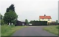
New Cottage on Brackenborough Road near Louth
Image: © Ian S
Taken: 21 Dec 2010
0.01 miles
3
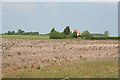
Farmland near Louth
Brackenborough Road zig-zags through this square. Counting from the south, I was standing on the 3rd right angled bend to take this photograph of New Cottage which stands on the 5th bend. The field directly in front of me was lying fallow. Note the trees round the building. This is typical of the Lincolnshire "flatlands" where a few well-placed trees give shelter from prevailing winds.
Image: © Kate Jewell
Taken: 6 Jun 2006
0.01 miles
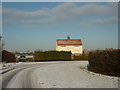
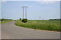
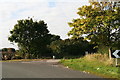
4
S bends on Brackenborough road near Louth
Image: © Steve Fareham
Taken: 2 Jun 2013
0.01 miles

6
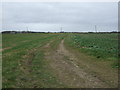
Farm track towards Keddington Grange
Off Brackenborough Road.
Image: © JThomas
Taken: 21 Mar 2015
0.07 miles
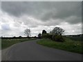
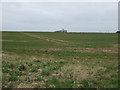
7
Brackenborough Road, near Louth
On the very edge of the Lincolnshire Wolds the land here is 28 metres above sea level. A few kilometres to the east and the land has dropped to 5 metres. Next stop, about 15 km as the bird flies, Saltfleet (Image) on the east coast. View from the 3rd bend to the 4th on this zig-zag road.
Image: © Kate Jewell
Taken: 6 Jun 2006
0.12 miles
9
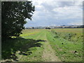
Farm track near Brackenborough
The roofs of the buildings of Louth's industrial fringe can just be seen in the distance with the Lincolnshire Wolds rising beyond.
Image: © Jonathan Thacker
Taken: 15 Aug 2014
0.16 miles
10
Brackenborough Road: the naughty corner
Not all pictures are of nice things: this corner suffers from the problems of all convenient but private parking spots: people dump rubbish there.
The main items are BEHIND the gate, so the Council is not responsible for clearing them.
You can see from the map that this is a road of many right-angle bends (like this one), which you might think strange in such a flat landscape. This was once marshy ground, and the original path followed the high, dry points in the marsh, which were obviously not in a straight line.
Image: © Chris
Taken: 10 Oct 2012
0.16 miles