IMAGES TAKEN NEAR TO
LN11 0FY
Introduction
This page details the photographs taken nearby to LN11 0FY by members of the Geograph project.
The Geograph project started in 2005 with the aim of publishing, organising and preserving representative images for every square kilometre of Great Britain, Ireland and the Isle of Man.

There are currently over 7.5m images from over14,400 individuals and you can help contribute to the project by visiting https://www.geograph.org.uk
Image Map (Loading...)


Getting Data...Please wait
Leaflet Map data © OpenStreetMap
Images are licensed for reuse under creativecommons.org/licenses/by-sa/2.0
Notes
- Clicking on the map will re-center to the selected point.
- The higher the marker number, the further away the image location is from the centre of the postcode.
Image Listing (13 Images Found)
Images are licensed for reuse under creativecommons.org/licenses/by-sa/2.0
Image
Details
Distance
1
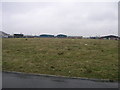
Fairfield Industrial Estate North
This part of Fairfield Industrial Estate still has some of the original field in evidence.
Image: © Michael Patterson
Taken: 8 Mar 2006
0.08 miles
2
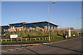
HM Revenue and Customs Office on Fairfield Industrial Estate
Lincoln Way, off Bolingbroke Road: this is where they have moved to from Louth centre.
The evocative Mediterranean-style landscaping does a lot to conceal the hard lines of the building.
Beware if are thinking of dropping in with your Tax Return (or for a friendly chat): the building is not exclusively theirs, and the HM Revenue office itself is only open a couple of days a week.
Image: © Chris
Taken: 23 Nov 2012
0.09 miles
3

Fairfield Enterprise Centre
Offices on Fairfield Industrial Estate
Image: © Richard Croft
Taken: 19 Nov 2008
0.10 miles
4
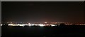
Acthorpe Top over Louth's Fairfield Road Industrial Estate to Mablethorpe
Mablethorpe in Image
Image: © Chris
Taken: 27 Oct 2016
0.10 miles
5
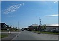
Bolingbroke Road, Fairfield Industrial Estate, Louth
Image: © Steve Fareham
Taken: 15 May 2014
0.10 miles
6
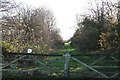
Disused railway through Fairfield Industrial Estate
The former line from Louth to Grimsby is a convenient route from Louth for people working on the estate.
The Lincolnshire Wolds Railway has plans to restore the line (it already operates the section from Fulstow to North Thoresby) although the final part, to the old Louth station, has been redeveloped.
See: http://www.lincolnshirewoldsrailway.co.uk/
Image: © Chris
Taken: 23 Nov 2012
0.13 miles
7

Fairfield Industrial Estate
North entrance to the growing industrial estate at Louth
Image: © Richard Croft
Taken: 19 Nov 2008
0.13 miles
8
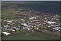
Fairfield Industrial Estate, aerial
Low centre is the northernmost of the two roundabouts that access the estate from the A16 Louth-Grimsby. Brackenborough Hall is visible top left. Barely visible in the centre is a communications mast, which stands next to the old railway track.
Image: © Chris
Taken: 7 Nov 2010
0.15 miles
9
Disused railway through Fairfield Industrial Estate
The former line from Louth to Grimsby is a convenient route from Louth for people working on the estate. Here the path heads north from the estate, towards Grimsby. It is not a public right of way although it is used as a path, and becomes a Permissive Bridleway a bit further up.
The Lincolnshire Wolds Railway has plans to restore the line (it already operates the section from Fulstow to North Thoresby) although the final part, to the old Louth station, has been redeveloped.
See: http://www.lincolnshirewoldsrailway.co.uk/
Image: © Chris
Taken: 23 Nov 2012
0.17 miles
10

Fairfield Industrial Estate
Businesses on Fairfield Industrial Estate
Image: © Richard Croft
Taken: 19 Nov 2008
0.19 miles