IMAGES TAKEN NEAR TO
Plover Grove, LOUTH, LN11 0BW
Introduction
This page details the photographs taken nearby to Plover Grove, LN11 0BW by members of the Geograph project.
The Geograph project started in 2005 with the aim of publishing, organising and preserving representative images for every square kilometre of Great Britain, Ireland and the Isle of Man.

There are currently over 7.5m images from over14,400 individuals and you can help contribute to the project by visiting https://www.geograph.org.uk
Image Map (Loading...)


Getting Data...Please wait
Leaflet Map data © OpenStreetMap
Images are licensed for reuse under creativecommons.org/licenses/by-sa/2.0
Notes
- Clicking on the map will re-center to the selected point.
- The higher the marker number, the further away the image location is from the centre of the postcode.
Image Listing (12 Images Found)
Images are licensed for reuse under creativecommons.org/licenses/by-sa/2.0
Image
Details
Distance
1
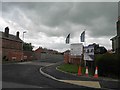
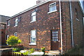
Dales way, new housing development off Brackenborough road, Louth
Image: © Steve Fareham
Taken: 2 Jun 2013
0.06 miles
2
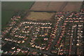
Housing off Brackenborough Road, Louth: aerial 2016
140+ houses have been approved behind these, and now another 400 are proposed.
The roads are narrow and crowded, and every house built at the top of the hill adds to the flooding problems for the houses at the bottom.
We are told the country needs affordable housing. Of the 140+ houses in the first development, only 43 are to be affordable. If the ratio were the same for the second development, that would mean a total of 300 new executive houses. So...where are 300 new executives to come from in this little town in rural Lincolnshire?
Having just defeated the dreadful "Southern Gateway" proposal of 970 houses on the other side of the town, Louth is faced with the misery and expense of yet another battle.
See also Image
Image: © Chris
Taken: 13 Mar 2016
0.09 miles
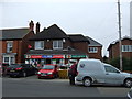
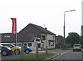
3

Brackenborough Road Post Office, Louth
This P.O. survived the government attrition, and has a thriving business based on the north west side of Louth.
Image: © Peter Church
Taken: 13 Sep 2012
0.14 miles
5

Old Direction Sign - Signpost by Brackenborough Road, Louth Parish
Ball finial - 2 arms; by the UC road, in parish of Louth (East Lindsey District), junction of Brackenborough Road with Keddington Road, against brick garden wall and hedge.
Surveyed
Milestone Society National ID: LI_TF3388.
Image: © Milestone Society
Taken: Unknown
0.19 miles

7
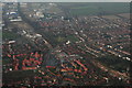
Louth North: aerial 2016
Aldi between the two estates of red houses. Brackenborough Road right. Fairfield Industrial Estate and disused railway top left.
Image: © Chris
Taken: 13 Mar 2016
0.20 miles
8
Former Railway Cottages
Former railwaymen's houses.
Image: © Robin Jones
Taken: 4 Oct 2006
0.23 miles
9
My Fathers Moustache
Unusual named public house on North Holme road Louth next to Shaws Motor dealer
Image: © John Firth
Taken: 11 Jun 2013
0.24 miles
10
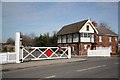
North Halt signalbox
Former signalbox on the dismantled Louth to Grimsby line, now a private residence
Image: © Richard Croft
Taken: 11 Mar 2009
0.24 miles