IMAGES TAKEN NEAR TO
Paradwys, BODORGAN, LL62 5PB
Introduction
This page details the photographs taken nearby to LL62 5PB by members of the Geograph project.
The Geograph project started in 2005 with the aim of publishing, organising and preserving representative images for every square kilometre of Great Britain, Ireland and the Isle of Man.

There are currently over 7.5m images from over14,400 individuals and you can help contribute to the project by visiting https://www.geograph.org.uk
Image Map
Images are licensed for reuse under creativecommons.org/licenses/by-sa/2.0
Notes
- Clicking on the map will re-center to the selected point.
- The higher the marker number, the further away the image location is from the centre of the postcode.
Image Listing (14 Images Found)
Images are licensed for reuse under creativecommons.org/licenses/by-sa/2.0
Image
Details
Distance
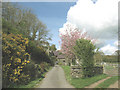
1
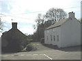
Ty'n Lon Uchaf in the hamlet of Paradwys
The road proceeds on towards to Ty Calch Farm
Image: © Eric Jones
Taken: 2 May 2008
0.02 miles
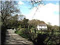
2
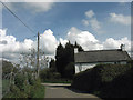
Approaching the road junction at Paradwys
The cottage on the right is Ty'n Lon Uchaf (= "upper homestead by the road").
Image: © Eric Jones
Taken: 2 May 2008
0.02 miles
3
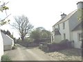
Yr Erw, Paradwys
The only traffic on the village street was a local farmer's quad bike.
Image: © Eric Jones
Taken: 1 Apr 2008
0.06 miles
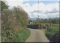
4
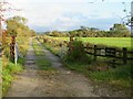
Farm track, Paradwys
One of two access tracks for Fferam Paradwys. The mainland mountains are just visible on the horizon.
Image: © Gordon Hatton
Taken: 23 Sep 2023
0.09 miles
7
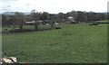
Ty Calch Farm from the Paradwys road
Ty Calch simply means "lime house". This is an area of Carboniferous Limestone. Limestone was quarried on the ridge above the house for agricultural purposes, some of it being transported to Caernarfonshire by sea.
Image: © Eric Jones
Taken: 2 May 2008
0.14 miles
8
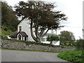
A corner of Paradise
Detached property below a limestone scar in the scattered community of Paradwys, which does translate as 'paradise'.
Image: © Gordon Hatton
Taken: 25 Sep 2020
0.16 miles
9
A sharp bend in the road near Llyswen
An entrance to a disused limestone quarry is situated at the bend.
Image: © Eric Jones
Taken: 2 May 2008
0.18 miles
10
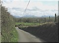
Road down the Carboniferous Limestone scarp in the direction of Paradwys
Image: © Eric Jones
Taken: 2 May 2008
0.19 miles