IMAGES TAKEN NEAR TO
Trefdraeth, BODORGAN, LL62 5HL
Introduction
This page details the photographs taken nearby to LL62 5HL by members of the Geograph project.
The Geograph project started in 2005 with the aim of publishing, organising and preserving representative images for every square kilometre of Great Britain, Ireland and the Isle of Man.

There are currently over 7.5m images from over14,400 individuals and you can help contribute to the project by visiting https://www.geograph.org.uk
Image Map
Images are licensed for reuse under creativecommons.org/licenses/by-sa/2.0
Notes
- Clicking on the map will re-center to the selected point.
- The higher the marker number, the further away the image location is from the centre of the postcode.
Image Listing (6 Images Found)
Images are licensed for reuse under creativecommons.org/licenses/by-sa/2.0
Image
Details
Distance
1
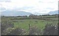
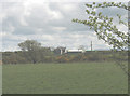
Pasture land between Bethel and Trefdraeth
This is predominantly an area of pastoral farming. The mountains of Snowdonia form a magnificent background. They are, from left to right, Snowdon (Yr Wyddfa), Moel Eilio, Yr Aran and Mynydd Mawr (Elephant Mountain).
Image: © Eric Jones
Taken: 2 May 2008
0.15 miles
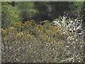
3
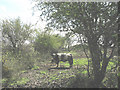
The point at which the path becomes impassable
Although sign posted from the road and accessed by a wooden stile, this path is badly neglected being muddy underfoot and frequently blocked by vegetation. Here,it becomes a sea of mud.
Image
Image: © Eric Jones
Taken: 2 May 2008
0.19 miles
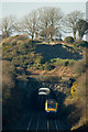
6
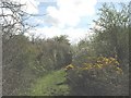
Footpath running parallel with the railway line
Image: © Eric Jones
Taken: 2 May 2008
0.23 miles