IMAGES TAKEN NEAR TO
Sling, Tregarth, BANGOR, LL57 4RJ
Introduction
This page details the photographs taken nearby to LL57 4RJ by members of the Geograph project.
The Geograph project started in 2005 with the aim of publishing, organising and preserving representative images for every square kilometre of Great Britain, Ireland and the Isle of Man.

There are currently over 7.5m images from over14,400 individuals and you can help contribute to the project by visiting https://www.geograph.org.uk
Image Map
Images are licensed for reuse under creativecommons.org/licenses/by-sa/2.0
Notes
- Clicking on the map will re-center to the selected point.
- The higher the marker number, the further away the image location is from the centre of the postcode.
Image Listing (19 Images Found)
Images are licensed for reuse under creativecommons.org/licenses/by-sa/2.0
Image
Details
Distance
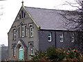
1
Gorffwysfa, the former Wesleyan Methodist chapel at Sling
Capel Gorffwysfa has been converted into a dwelling.
Image
Image: © Eric Jones
Taken: 31 May 2008
0.01 miles
2
Disused water tap alcove, Sling
The water tap mechanism has been removed from this alcove.
Image: © Meirion
Taken: 21 Mar 2019
0.08 miles
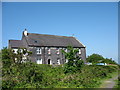
4
Old chapel in Sling
Old chapel in Sling which has been converted for residential use
Image: © Nigel Williams
Taken: 25 Jan 2006
0.12 miles
5
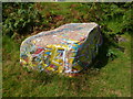
Painted boulder, Y Parc, Sling
A rather worn but still colourful painted boulder in Y Parc, Sling.
Image: © Meirion
Taken: 23 Aug 2016
0.12 miles
6
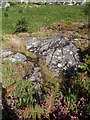
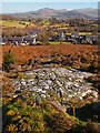
A section of the Parc Moelyci rock cannon, Sling
A section of the rock cannon (Craig fagnel) in Parc Moelyci, Sling. (See also: Image).
Image: © Meirion
Taken: 23 Aug 2016
0.12 miles
7
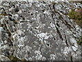
Parc Moelyci rock cannon (close-up of some of the holes), Sling
A close-up of some of the holes (there are 195 in total) in the Parc Moelyci rock cannon, Sling. (See also Image)
Image: © Meirion
Taken: 23 Aug 2016
0.12 miles
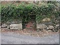
8
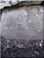
Benchmark near Sling farmhouse, Sling
This benchmark is located on the SW side of the road in the boundary wall of a building referred to as 'Sling farmhouse' on old maps of the area. The mark is not in the current Ordnance Survey database but is shown on an 1970-72 map of the area at a height of 189.09m above the Newlyn datum.
Image: © Meirion
Taken: 8 Apr 2011
0.13 miles
10
Footpath east of Sling
This one of many paths in the area which were constructed to link the hillside settlements with the Penrhyn Quarry.
Image: © Eric Jones
Taken: 31 May 2008
0.14 miles