IMAGES TAKEN NEAR TO
Tregarth, BANGOR, LL57 4NS
Introduction
This page details the photographs taken nearby to LL57 4NS by members of the Geograph project.
The Geograph project started in 2005 with the aim of publishing, organising and preserving representative images for every square kilometre of Great Britain, Ireland and the Isle of Man.

There are currently over 7.5m images from over14,400 individuals and you can help contribute to the project by visiting https://www.geograph.org.uk
Image Map
Images are licensed for reuse under creativecommons.org/licenses/by-sa/2.0
Notes
- Clicking on the map will re-center to the selected point.
- The higher the marker number, the further away the image location is from the centre of the postcode.
Image Listing (25 Images Found)
Images are licensed for reuse under creativecommons.org/licenses/by-sa/2.0
Image
Details
Distance
2
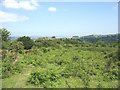
Bracken, rough grazing and rock outcrop
The rock outcrop, formed of Bronllwyd Grits, is named on large scale maps as Mynydd Llandegai (Llandegai Mountain). It should not to be confused with the village of Mynydd Llandegai some 2kms to the south.
Image: © Eric Jones
Taken: 31 May 2008
0.10 miles
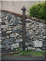
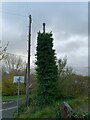
3
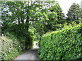
The bottom of Lon Hafodty
This is a narrow lane signed as being "unsuitable to wide vehicles".
Image: © Eric Jones
Taken: 31 May 2008
0.12 miles
4
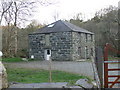
Melin Coetmor
Former corn mill on the bank of the River Ogwen
Image: © Eirian Evans
Taken: 23 Apr 2008
0.13 miles
6
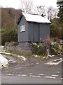
Hendurnpike Crossing, Near Tregarth
A crossing-keeper’s hut on the route of the Penrhyn Railway.
Image: © Chris Andrews
Taken: 10 Dec 2017
0.15 miles
9
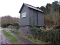
Crossing-keeper's cabin, Hen-durnpike
The wooden Crossing-keeper's cabin for the former Hen-durnpike Penrhyn Quarry Railway level crossing.
Image: © Meirion
Taken: 18 Mar 2019
0.16 miles