IMAGES TAKEN NEAR TO
Waunfawr, CAERNARFON, LL55 4SD
Introduction
This page details the photographs taken nearby to LL55 4SD by members of the Geograph project.
The Geograph project started in 2005 with the aim of publishing, organising and preserving representative images for every square kilometre of Great Britain, Ireland and the Isle of Man.

There are currently over 7.5m images from over14,400 individuals and you can help contribute to the project by visiting https://www.geograph.org.uk
Image Map
Images are licensed for reuse under creativecommons.org/licenses/by-sa/2.0
Notes
- Clicking on the map will re-center to the selected point.
- The higher the marker number, the further away the image location is from the centre of the postcode.
Image Listing (5 Images Found)
Images are licensed for reuse under creativecommons.org/licenses/by-sa/2.0
Image
Details
Distance
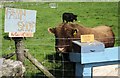
1
The road to Waunfawr, at the 201 metre spot height
With the Elephant [Mynydd Mawr] on the horizon.
Image: © Christine Johnstone
Taken: 22 Nov 2014
0.22 miles
2
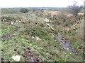
Dros y gors
In theory at least, a footpath runs at the side of this small stream which descends from the Ceunant road towards the boggy valley. Large, glacially-derived boulders have been turned up where the stream has been deepened for drainage.
Image: © Jonathan Wilkins
Taken: 14 Oct 2011
0.24 miles
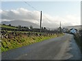
3
Tan yr Allt, between Ceunant and Waunfawr
On the east side of the road. The house name translates as 'Below the hill'.
Image: © Christine Johnstone
Taken: 22 Nov 2014
0.24 miles
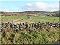
4
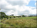
View past Fferm Hafod Rhug towards Monte Verita
This photo shows the improving quality of the land as one rises up the slope - from marshland at the bottom, through grazing land, to hay fields behind the farmhouse. Monte Verita, surrounded by conifers, is a prominent landmark on the spur. The mountain in the background is Moel Eilio.
Image: © Eric Jones
Taken: 12 Aug 2006
0.24 miles