IMAGES TAKEN NEAR TO
Nantlle, CAERNARFON, LL54 6BT
Introduction
This page details the photographs taken nearby to LL54 6BT by members of the Geograph project.
The Geograph project started in 2005 with the aim of publishing, organising and preserving representative images for every square kilometre of Great Britain, Ireland and the Isle of Man.

There are currently over 7.5m images from over14,400 individuals and you can help contribute to the project by visiting https://www.geograph.org.uk
Image Map (Loading...)


Getting Data...Please wait
Leaflet Map data © OpenStreetMap
Images are licensed for reuse under creativecommons.org/licenses/by-sa/2.0
Notes
- Clicking on the map will re-center to the selected point.
- The higher the marker number, the further away the image location is from the centre of the postcode.
Image Listing (18 Images Found)
Images are licensed for reuse under creativecommons.org/licenses/by-sa/2.0
Image
Details
Distance
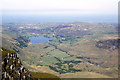
2
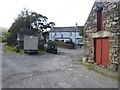
Farm and fields at Tal-y-mignedd
Tal-y-mignedd is a farm in the Nantlle valley; it's seen here from above on the B4418.
Image: © Trevor Littlewood
Taken: 5 Sep 2013
0.04 miles
3
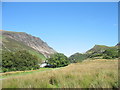
Tal-y-mignedd and Cwmyffynnon, Eryri
Tal-y-mignedd Farm, below the peaks Mynydd Drws-y-coed, Trum y Ddysgl and Mynydd Tal-y-mignedd, and the glaciated valley Cwmyffynnon. Ref:PC200070.
Image: © Phil Brandon Hunter
Taken: 20 Dec 2022
0.04 miles
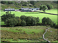
4
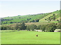
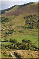
Fertile fields, Tal-y-Mignedd Isaf
Areas surrounding farms tend to be more fertile and have been enclosed by dry stone walls. These fields are used for producing fodder crops for feeding livestock through the winter and also used for holding livestock brought down from the surrounding rough grazing or moorland for dipping, shearing, tupping, lambing and sorting for sale.
Image: © Eirian Evans
Taken: 14 Nov 2008
0.05 miles
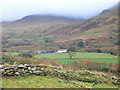
5
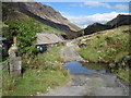
Ford at Tal-y-mignedd farm
With the crags of Craig y Bera in the distance.
Image: © David Medcalf
Taken: 20 Sep 2009
0.06 miles
7
Y Bwgan Brain - The Scarecrow
A scarecrow looking forlorn in a field of newly sown grass
Image: © Eric Jones
Taken: 8 Sep 2006
0.10 miles
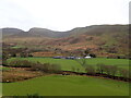
8
Looking East Towards Tal-y-mignedd-isaf
This photo shows the poor quality of the natural vegetation in this area and reason why farmers plant grasses for pasturage. The mountain on the left of the photograph is Mynydd Mawr.
Image: © Eric Jones
Taken: 8 Sep 2006
0.10 miles
9
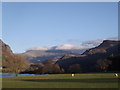
Dyffryn Nanttle ...Nantlle Valley
A late November day with the rare combination of blue skies and fairly warm weather.
Looking east from the B4418 near Nantlle.
Past sheep grazing on the grassland by Llyn Nantlle Uchaf; and on up the Nantlle Valley towards clouds drifting over the tops of the Snowdon massif in the distance
Image: © I Love Colour
Taken: 27 Nov 2014
0.12 miles
10
View to Mynydd Tal-y-mignedd
Mynydd Tal-y-mignedd viewed from across the valley, just visible on the summit is the large cairn or obelisk which adorns it.
Image: © Philip Halling
Taken: 15 Aug 2014
0.12 miles