IMAGES TAKEN NEAR TO
Bwlchtocyn, PWLLHELI, LL53 7BW
Introduction
This page details the photographs taken nearby to LL53 7BW by members of the Geograph project.
The Geograph project started in 2005 with the aim of publishing, organising and preserving representative images for every square kilometre of Great Britain, Ireland and the Isle of Man.

There are currently over 7.5m images from over14,400 individuals and you can help contribute to the project by visiting https://www.geograph.org.uk
Image Map
Images are licensed for reuse under creativecommons.org/licenses/by-sa/2.0
Notes
- Clicking on the map will re-center to the selected point.
- The higher the marker number, the further away the image location is from the centre of the postcode.
Image Listing (12 Images Found)
Images are licensed for reuse under creativecommons.org/licenses/by-sa/2.0
Image
Details
Distance
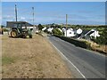
1
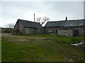
Old farm buildings
On the single track road from Bwlchtocyn down towards Abersoch.
Image: © Peter Barr
Taken: 1 May 2012
0.07 miles
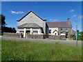
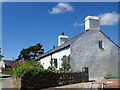
2
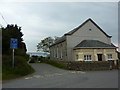
Chapel at Bwlchtocyn
Dated 1796, with an extension, a porch, in 1912.A single track road leads down towards Abersoch Golf Course.
Image: © Peter Barr
Taken: 1 May 2012
0.10 miles
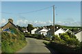
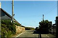
5
Modern housing, Bwlchtocyn
The growth of the semi-rural population of the district is extraordinary when compared with succeeding editions of the old OS maps which show almost no change in the district from Victorian times until after the Second World War.
Image: © Jonathan Wilkins
Taken: 20 Jul 2022
0.13 miles
7
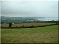
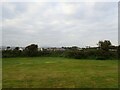
Farmland looking towards Borth Fawr
Borth Fawr is the beach south of Abersoch.
Image: © David Medcalf
Taken: 27 Jun 2006
0.15 miles
9
Bwlchtocyn seen from Berthddu campsite
Image: © Eirian Evans
Taken: 12 Jun 2021
0.18 miles
10
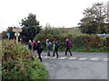
Ger Machroes / Near Machroes
Cerddwyr yn croesi cilfordd wrth fynd i gyfeiriad Machroes.
Walkers crossing a byway while heading in the direction of Machroes.
Image: © Alan Richards
Taken: 14 Sep 2017
0.22 miles