IMAGES TAKEN NEAR TO
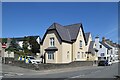
Lleyn Street, PWLLHELI, LL53 5SW
Introduction
This page details the photographs taken nearby to Lleyn Street, LL53 5SW by members of the Geograph project.
The Geograph project started in 2005 with the aim of publishing, organising and preserving representative images for every square kilometre of Great Britain, Ireland and the Isle of Man.

There are currently over 7.5m images from over14,400 individuals and you can help contribute to the project by visiting https://www.geograph.org.uk
Image Map
Images are licensed for reuse under creativecommons.org/licenses/by-sa/2.0
Notes
- Clicking on the map will re-center to the selected point.
- The higher the marker number, the further away the image location is from the centre of the postcode.
Image Listing (426 Images Found)
Images are licensed for reuse under creativecommons.org/licenses/by-sa/2.0
Image
Details
Distance
1
Penlon Llŷn
From the end of Stryd Fawr Penlon Llŷn was, in the past, the main route from Pwllheli westwards along the high ground towards Aberdaron. It avoided the marshy coastal ground which the present A499 follows.
Image: © Alan Fryer
Taken: 4 Nov 2012
0.03 miles
2
Lon Lleyn, Pwllheli
As the name suggests, this was for a long time the gateway to Lleyn.
Image: © Eric Jones
Taken: 5 Aug 2010
0.05 miles
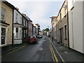
3
View east along Lon Lleyn in the direction of the High Street
Image: © Eric Jones
Taken: 5 Aug 2010
0.05 miles
4
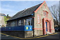
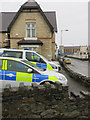
Heddlu Pwllheli (Pwllheli Police Station)
The 'multiplex' (https://www.sabre-roads.org.uk/wiki/index.php?title=Multiplex ) dual designation A497/A499, the main road through the town, is to the right: https://www.sabre-roads.org.uk/wiki/index.php?title=A497 .
Image: © Bill Harrison
Taken: 9 Jul 2022
0.06 miles

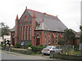
6
Capel y Wyrcws Pwllheli Workhouse Chapel
The chapel built for Image in the south east corner of the workhouse site. Now part of the hospital which uses the site.
Image: © Alan Fryer
Taken: 5 Feb 2008
0.06 miles
7
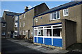
Hen Wyrcws Pwllheli Old Workhouse
The centre of the cruciform buildings of Image The yard in the picture was matched by others to the left and rear.
Image: © Alan Fryer
Taken: 5 Feb 2008
0.07 miles
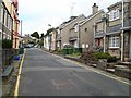
8
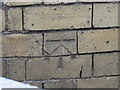
Bench mark on Pwllheli Police Station
This Ordnance Survey cut bench mark is on the gable end of the Police Station. See also Image
Image: © John S Turner
Taken: 5 Nov 2015
0.07 miles
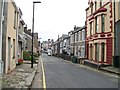
9
Pwllheli Police Station
Looking east towards Pwllheli Police Station and car park. There is an Ordnance Survey bench mark on the gable of the building facing the camera - see Image
Image: © John S Turner
Taken: 5 Nov 2015
0.07 miles