IMAGES TAKEN NEAR TO
North Terrace, PWLLHELI, LL53 5EW
Introduction
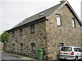
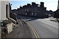
This page details the photographs taken nearby to North Terrace, LL53 5EW by members of the Geograph project.
The Geograph project started in 2005 with the aim of publishing, organising and preserving representative images for every square kilometre of Great Britain, Ireland and the Isle of Man.

There are currently over 7.5m images from over14,400 individuals and you can help contribute to the project by visiting https://www.geograph.org.uk
Image Map (Loading...)


Getting Data...Please wait
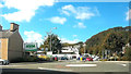
Leaflet Map data © OpenStreetMap
Images are licensed for reuse under creativecommons.org/licenses/by-sa/2.0
Notes
- Clicking on the map will re-center to the selected point.
- The higher the marker number, the further away the image location is from the centre of the postcode.
Image Listing (315 Images Found)
Images are licensed for reuse under creativecommons.org/licenses/by-sa/2.0
Image
Details
Distance
1
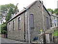
Hen Neuadd y Deyrnas Tystion Jehofa - Former Kingdom Hall of Jehovah's Witnesses
Closed when the Jehovah's Witnesses on the peninsula moved to a new building in Porthmadog.
Image: © Alan Fryer
Taken: 18 Sep 2015
0.01 miles
2
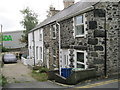
Tanrallt
A short terrace off Pentre Poeth/North Street on the edge of what was, in the early days of the town, the pwll heli or salt-water pool. Now convenient for Asda!
Image: © Alan Fryer
Taken: 18 Sep 2015
0.04 miles
3
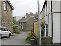
Llawr Gors
A terrace which takes its name from the Cors (marsh) which was the pwll heli (salt-water pool) from which the town took its name.
Image: © Alan Fryer
Taken: 18 Sep 2015
0.05 miles
4
Yr Hen Gapel - The Old Chapel
Former Baptist chapel on Pentre Poeth/North Street, now much altered and converted to residential use. When it was closed in the 1980s the bodies from the graveyard were re-interred in the cemetery at Deneio Image
Image: © Alan Fryer
Taken: 18 Sep 2015
0.05 miles
5
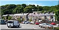
The rear of houses in Pentre Poeth from Asda's car park
Pentre Poeth means "hot village". Its English name is the more prosaic - just plain North Street.
Image: © Eric Jones
Taken: 25 Jun 2010
0.05 miles
6
Pwllheli Milestone
Old milestone next to white wall lower left hand corner on the A499 at Pwllheli, Gwynedd. For close up view see http://www.geograph.org.uk/photo/5634704
Image: © Keith Evans
Taken: 19 Sep 2017
0.05 miles
7
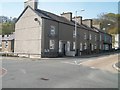
Terrace of houses at Penlon Caernarfon, Pwllheli
Image: © Eric Jones
Taken: 23 Apr 2010
0.05 miles
8
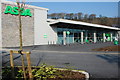
Archfarchnad newydd Asda Pwllheli New Asda supermarket
The new supermarket was built in 2006 after much opposition from local traders. It is built on Y Gors (the marsh), site of the original pwll heli (saltwater pool). The main town drain runs under the building; some locals await heavy rain with interest.
Image: © Alan Fryer
Taken: 27 Mar 2007
0.05 miles
9
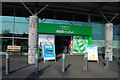
Asda newydd Pwllheli new Asda
Dubbed ASDRWG by local opponents. DA means "good", DRWG means "bad".
Image: © Alan Fryer
Taken: 27 Mar 2007
0.06 miles