IMAGES TAKEN NEAR TO
High Street, CRICCIETH, LL52 0BS
Introduction
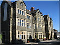
This page details the photographs taken nearby to High Street, LL52 0BS by members of the Geograph project.
The Geograph project started in 2005 with the aim of publishing, organising and preserving representative images for every square kilometre of Great Britain, Ireland and the Isle of Man.

There are currently over 7.5m images from over14,400 individuals and you can help contribute to the project by visiting https://www.geograph.org.uk
Image Map
Images are licensed for reuse under creativecommons.org/licenses/by-sa/2.0
Notes
- Clicking on the map will re-center to the selected point.
- The higher the marker number, the further away the image location is from the centre of the postcode.
Image Listing (421 Images Found)
Images are licensed for reuse under creativecommons.org/licenses/by-sa/2.0
Image
Details
Distance
1
Former chapel on High Street, Criccieth
Now the home of furniture auctioneers. It is ironic that it has a For sale sign at the front.
Image: © Bill Boaden
Taken: 30 Mar 2012
0.01 miles
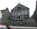
2
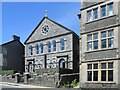
Former Capel Mawr Calvinistic Methodist Chapel, High Street, Criccieth
Probably built around 1822 and Grade II listed by Cadw (15371 https://cadwpublic-api.azurewebsites.net/reports/listedbuilding/FullReport?lang=&id=15371 ). Now in residential use.
Image: © Bill Harrison
Taken: 9 Jul 2022
0.01 miles
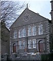
3
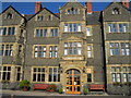
George IV Hotel, Criccieth
Now closed and awaiting builders to convert the hotel into residential units and apartments.
Image: © Chris Heaton
Taken: 3 Oct 2020
0.01 miles
4
Gwesty George IV Hotel
The hotel is undergoing a long process of refurbishment under new owners.
Image: © Alan Fryer
Taken: 7 Nov 2011
0.01 miles
5
Capel Mawr Criccieth
The large chapel is now an auction room.
Image: © Alan Fryer
Taken: 28 Feb 2007
0.01 miles
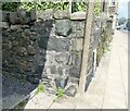
6
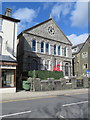
Former Capel Mawr, High Street, Criccieth
This former Calvinistic Methodist Chapel has more recently been an auction house and Collectors Centre. It was sold early in 2017. There is an Ordnance Survey bench mark on the south west corner of the building, in the shadow - Image
Image: © John S Turner
Taken: 20 Mar 2017
0.01 miles
7
Capel Mawr
A Grade II listed https://cadwpublic-api.azurewebsites.net/reports/listedbuilding/FullReport?lang=en&id=15371 at 21 High Street, Criccieth. A Calvinistic Methodist Chapel: registers show that a chapel was in existence as early as 1813, although the Religious Census of 1851 suggests that the chapel building was erected in about 1822 - the Tithe Map of 1839 records a chapel on this site. The Sunday School to the rear was built between 1889 and 1900. The father of Margaret Owen (wife of David Lloyd George), was a deacon at Capel Mawr, and led a secession from the chapel to build a second chapel (Capel Seion) in 1887-8.
It became disused in the 1990s and in recent years it was home to Rousells Antiques and Auctions.
Around 2018 it was converted into apartments and is now used as an AirB&B.
Image: © Gerald England
Taken: 9 Jul 2023
0.01 miles
8
Site of former benchmark
In 2017 John S Turner Image recorded an Ordnance Survey bench mark on the south west corner of the former Capel Mawr, Calvinistic Methodist Chapel, High Street, Criccieth. It doesn't appear to be there anymore.
Image: © Gerald England
Taken: 12 Jul 2023
0.01 miles
9
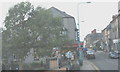
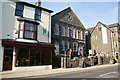
The western half of Criccieth's High Street
The building in the background right is the George IV Hotel.
http://www.georgeivhotel.com/
Image: © Eric Jones
Taken: 5 Jan 2008
0.01 miles