IMAGES TAKEN NEAR TO
Aberamffra Road, BARMOUTH, LL42 1TB
Introduction
This page details the photographs taken nearby to Aberamffra Road, LL42 1TB by members of the Geograph project.
The Geograph project started in 2005 with the aim of publishing, organising and preserving representative images for every square kilometre of Great Britain, Ireland and the Isle of Man.

There are currently over 7.5m images from over14,400 individuals and you can help contribute to the project by visiting https://www.geograph.org.uk
Image Map
Images are licensed for reuse under creativecommons.org/licenses/by-sa/2.0
Notes
- Clicking on the map will re-center to the selected point.
- The higher the marker number, the further away the image location is from the centre of the postcode.
Image Listing (447 Images Found)
Images are licensed for reuse under creativecommons.org/licenses/by-sa/2.0
Image
Details
Distance
1
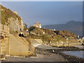
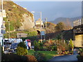
Railway embankment and tunnel Barmouth Harbour
Looking towards Penralt Hotel (Tall building in distant centre). Concrete railway bridge and stone embankment leading to the tunnel then sweeping south towards the viaduct.
Image: © David Bowen
Taken: 6 Jan 2007
0.01 miles
3
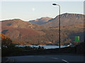
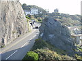
Road with a view A496 heading east out of Barmouth
5.30pm 23rd October 2007 looking south east across the Mawddach Estuary from Aberamffra Rd (A496) Barmouth. The view takes in Arthog, Tyddyn Mawr, The fort on Pared y cefn hir (left), Tyrau Mawr (right) (Gregennen Lake is at the foot of this mountain) and then Cader (Idris far centre).
Image: © David Bowen
Taken: 23 Oct 2007
0.01 miles
4
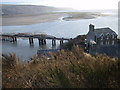
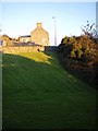
Barmouth bridge and Penrallt House from Aberamfra Hill.
Views of the bridge, and Penrallt House from the hill above Borthwen Terrace. Fairbourne is in the middle ground and Llwyngwril is in the distance. Picture 4pm 10th March 2007.
Image: © David Bowen
Taken: 10 Mar 2007
0.01 miles
5
Penralt House from St David's Church, Barmouth
This view looking east takes in the public gardens outside the Last Inn which run parallel to the concrete railway bridge on the harbour. To the left the line of main road A496 can be seen as it zigzags left then right over the railway tunnel. A further 300m is Penralt House where the road bends again on Aberamffra Hill. In the distance is Cader Idris. Picture 6th January 2007.
Image: © David Bowen
Taken: 6 Jan 2007
0.01 miles
6

Orielton Hall Gardens from the secret beach
Orielton Hall (centre) Borthwen Terrace (right) Lawrenny Lodge Hotel (left). Picture taken from below the railway with back to the secret beach. Picture 3.30pm 22nd October 2007.
Image: © David Bowen
Taken: 22 Oct 2007
0.01 miles
7
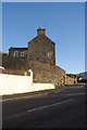
West gable end of Borthwen Terrace from Orielton Gardens
Western gable end of Borthwen Terrace from Orielton Gardens. The other side of the wall which runs diagonally across the picture is Aberamffra Rd (A496). Penralt House is just out of shot to the far right, Porking Terrace is behind me. Picture 4.30 23rd October 2007.
Image: © David Bowen
Taken: 23 Oct 2007
0.01 miles
8
Aberamffra Hill from the rock above the railway tunnel, Barmouth
Aberamffra Hill from the rock above the railway tunnel, Barmouth. Orielton Hall can be seen (white building) with Penralt far right. The road in the foreground travels past Porkington Terrace which is just out of sight to the left. Picture 27th September 2007.
Image: © David Bowen
Taken: 28 Sep 2007
0.01 miles
9
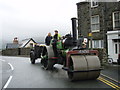
I hope you've got dual controls on that mate!
Image: © David Bowen
Taken: 18 Aug 2007
0.01 miles
10
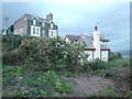
No.1 Borthwen Terrace, Aberamffra Rd, Barmouth
Image: © David Bowen
Taken: 26 Dec 2008
0.01 miles