IMAGES TAKEN NEAR TO
DOLGELLAU, LL40 1TH
Introduction
This page details the photographs taken nearby to LL40 1TH by members of the Geograph project.
The Geograph project started in 2005 with the aim of publishing, organising and preserving representative images for every square kilometre of Great Britain, Ireland and the Isle of Man.

There are currently over 7.5m images from over14,400 individuals and you can help contribute to the project by visiting https://www.geograph.org.uk
Image Map
Images are licensed for reuse under creativecommons.org/licenses/by-sa/2.0
Notes
- Clicking on the map will re-center to the selected point.
- The higher the marker number, the further away the image location is from the centre of the postcode.
Image Listing (9 Images Found)
Images are licensed for reuse under creativecommons.org/licenses/by-sa/2.0
Image
Details
Distance
1
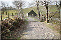
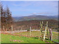
Passing through Gellilwyd Fawr Farm
This is the start of a green lane over the hills to Kings Youth Hostel. The OS route mark the route with green dots as an 'other route' open to all vehicles, but I would suggest that you not try it with a four-wheel drive! Motorcycles would find it an interesting challenge. The route crosses access land as far as Hafod-dywyll. The stile in the view has been dispensed with - access is through the gate.
Image: © John Lucas
Taken: 24 Mar 2022
0.03 miles
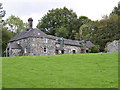
2
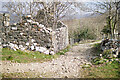
A ruined barn at Gellilwyd Fawr
Viewed from the start of the green lane over the hills to Kings Youth Hostel.
Image: © John Lucas
Taken: 24 Mar 2022
0.04 miles
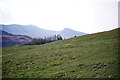
3
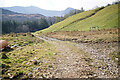
A track on Gellilwyd Farm
This is a right of way leading south to Llyn Gwernan. It is not the green lane to Kings.
Image: © John Lucas
Taken: 24 Mar 2022
0.08 miles
4
On the green lane up from Gellilwyd Fawr
Looking back down the steep hill that rises from the farm.
Image: © John Lucas
Taken: 24 Mar 2022
0.08 miles
5
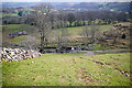
Camfa uwchben Gellilwyd / Stile above Gellilwyd
Golygfa tuag at Dolgellau / View towards Dolgellau.
Image: © Ian Medcalf
Taken: 12 Nov 2011
0.11 miles
6
Approaching the forest above Llyn Gwernan
Image: © Eric Jones
Taken: 19 Jul 2006
0.14 miles
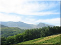
7
Pasture above Gellilwyd
This is all access land. Cadair Idris in the distance.
Image: © John Lucas
Taken: 24 Mar 2022
0.15 miles
8
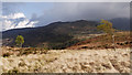
Isolated trees on grassy moorland
The location is south-west of Dolgellau. The hill beyond rises to over 500m but appears unnamed on OS maps; it's just a minor outlier of the Cadair Idris range with little prominence of its own.
Image: © Trevor Littlewood
Taken: 19 Apr 2012
0.19 miles
9
Gellilwyd Fach.
A handsome farmhouse built in an unusual, but interesting design.
Image: © Hefin Richards
Taken: 24 Sep 2006
0.24 miles