IMAGES TAKEN NEAR TO
Baclaw Lane, CONWY, LL32 8UA
Introduction
This page details the photographs taken nearby to Baclaw Lane, LL32 8UA by members of the Geograph project.
The Geograph project started in 2005 with the aim of publishing, organising and preserving representative images for every square kilometre of Great Britain, Ireland and the Isle of Man.

There are currently over 7.5m images from over14,400 individuals and you can help contribute to the project by visiting https://www.geograph.org.uk
Image Map
Images are licensed for reuse under creativecommons.org/licenses/by-sa/2.0
Notes
- Clicking on the map will re-center to the selected point.
- The higher the marker number, the further away the image location is from the centre of the postcode.
Image Listing (6 Images Found)
Images are licensed for reuse under creativecommons.org/licenses/by-sa/2.0
Image
Details
Distance
1
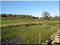
Fields below Brwyn Gwylan
Fine-looking pasture slopes down to a substantial wall at the edge of the estuary. A significant bank marks a much earlier shoreline some distance above the present maximum tidal and flood-level.
Image: © Jonathan Wilkins
Taken: 14 Nov 2014
0.14 miles
2
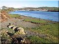
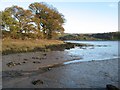
Afon Conwy shore 2
Shoreline of the Conwy estuary below Tyddyn Cynal which is gently shelving turf growing on muddy, fluvio-glacial gravel overlying till. In the distance on the opposite side of the river is Glany Conwy.
Image: © Jonathan Wilkins
Taken: 14 Nov 2014
0.19 miles
3
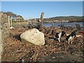
Glacial erratic boulder
Nestling in a thick bed of reedy detritus at the flood level is a superb glacial erratic boulder, typical of those transported by the last glacier to flow in the Conwy Valley. Unlike those which have been lifted to build the estuary wall, this one is too large to handle and has been left essentially where it was dropped 10,000 years ago when the ice melted.
Image: © Jonathan Wilkins
Taken: 14 Nov 2014
0.20 miles
4
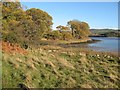
Afon Conwy shore 1
I am grateful to the landowner for permission to capture this image from the largely inaccessible western shore of the lower Conwy estuary. Pasture slopes down from Fachleidiog to a line of mature trees at the historical boundary, now rather tumbled about. Despite the late date, many trees are still holding onto their leaves.
Image: © Jonathan Wilkins
Taken: 14 Nov 2014
0.21 miles
5
Low tide mud
The ebbing tide is exposing a wide, muddy margin on this sheltered inlet. Much of the Conwy estuary is a superb and secluded habitat for birds.
Image: © Jonathan Wilkins
Taken: 14 Nov 2014
0.21 miles
6
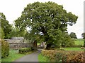
Farm buildings, Fachleidiog
Above the Conwy estuary on the west bank.
Image: © Steve Fareham
Taken: 19 Oct 2010
0.21 miles