IMAGES TAKEN NEAR TO
Neville Place, LLANDUDNO, LL30 3BL
Introduction
This page details the photographs taken nearby to Neville Place, LL30 3BL by members of the Geograph project.
The Geograph project started in 2005 with the aim of publishing, organising and preserving representative images for every square kilometre of Great Britain, Ireland and the Isle of Man.

There are currently over 7.5m images from over14,400 individuals and you can help contribute to the project by visiting https://www.geograph.org.uk
Image Map (Loading...)


Getting Data...Please wait
Leaflet Map data © OpenStreetMap
Images are licensed for reuse under creativecommons.org/licenses/by-sa/2.0
Notes
- Clicking on the map will re-center to the selected point.
- The higher the marker number, the further away the image location is from the centre of the postcode.
Image Listing (61 Images Found)
Images are licensed for reuse under creativecommons.org/licenses/by-sa/2.0
Image
Details
Distance
1
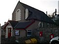
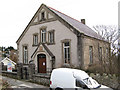
Penrhyn Side Village Hall
Formerly a chapel, the building was converted for use by the community.
Image: © Eirian Evans
Taken: 28 Jan 2012
0.02 miles
2
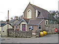
Village hall
The present village hall occupies a building that was originally a chapel. Elements of the architecture, especially the windows, are instantly recognisable. Originally the Ebenezer chapel, dated to 1892 by the stone plaque, the conversion for use as a village hall goes back to 1977.
Image: © Jonathan Wilkins
Taken: 21 Jan 2011
0.03 miles
3
Cross Keys and chapel
The Cross Keys is one of two pubs in the village, the other is the Penrhyn Arms. The narrow, north-facing frontage is not conducive to photography, so to avoid deep shadow obscuring details a bright, but cloudy day has been chosen. Some disquiet may have arisen from the proximity of the chapel.
Image: © Jonathan Wilkins
Taken: 21 Jan 2011
0.04 miles
4

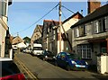
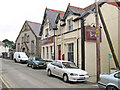
Centre of Penrhynside village
The main road through this old village passes two pubs and four ex-chapels.
Image: © GP Williams
Taken: 7 Sep 2009
0.04 miles
5
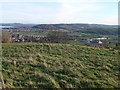
View from above Penrhyn Side
Prominent in the centre of the photo is Bryn Euryn where there was once a hill fort.
Image: © Eirian Evans
Taken: 28 Jan 2012
0.04 miles
6
Capel Calfaria
Four chapels are shown in maps of the village, but none are now in use for worship. This one, the Baptists' chapel, has seen the most recent use, apparently. At the time of imaging, a notice was pinned to the door advising disposal of the property by the trustees, dated July 2010. The notice of sale of the chapel site by auction gives an October 2010 date, but it must be supposed that the sale was not a success, although a private bid has been successful since that time.
The stone plaque over the entrance, poorly repaired with cement, reads "WELSH BAPTIST CHAPEL PENRHYNSIDE A.D.1894" while the notice board reads "CALFARIA Addoldy Y Bedyddwyr"
Image: © Jonathan Wilkins
Taken: 21 Jan 2011
0.06 miles
8
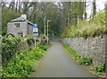
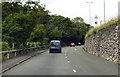
North Lodge along National Cycle Network Route 5
Image: © Mat Fascione
Taken: 16 Apr 2019
0.08 miles