
IMAGES TAKEN NEAR TO
Geulan Road, COLWYN BAY, LL29 8DX
Introduction
This page details the photographs taken nearby to Geulan Road, LL29 8DX by members of the Geograph project.
The Geograph project started in 2005 with the aim of publishing, organising and preserving representative images for every square kilometre of Great Britain, Ireland and the Isle of Man.

There are currently over 7.5m images from over14,400 individuals and you can help contribute to the project by visiting https://www.geograph.org.uk
Image Map
Images are licensed for reuse under creativecommons.org/licenses/by-sa/2.0
Notes
- Clicking on the map will re-center to the selected point.
- The higher the marker number, the further away the image location is from the centre of the postcode.
Image Listing (12 Images Found)
Images are licensed for reuse under creativecommons.org/licenses/by-sa/2.0
Image
Details
Distance
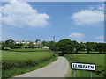
2
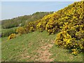
Gorse in bloom
Bright-yellow Gorse blooms fill the air with a sweet, coconut scent (not that you can experience that here). In the distance, woodland covers the valley side with a mixture of species coming into blossom or leaf progressively. Spring at its best!
Image: © Jonathan Wilkins
Taken: 20 Apr 2011
0.16 miles
3

Pentwr taclus o goed / A neat pile of logs
Image: © Ceri Thomas
Taken: 10 Dec 2011
0.19 miles
4
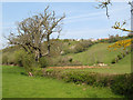
Valley bottom
A large, dead oak tree dominates the hedge alongside the small stream. Further on, a pool has been dug in the damp, rushy ground of the valley floor. Pasture occupies all of the land on both sides of the valley.
Image: © Jonathan Wilkins
Taken: 20 Apr 2011
0.20 miles
5
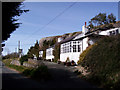
The Castle Inn
A very low-key establishment nestling below the cliffs remaining from extensive quarrying in the past.
Image: © Jonathan Wilkins
Taken: 19 Mar 2008
0.22 miles
6
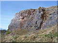
Carboniferous Limestone
Great thicknesses of limestone of Carboniferous age (~350 million years) remain in the coastal hills in this area. Quarries on the south-facing slopes are no longer active, but serious extraction continues on the coast. The limestone is the result of accumulation of carbonate-rich muds from microscopic algae and shelly debris forming obvious fossils. Here the layers of the rock can be seen to dip steadily to the North.
Image: © Jonathan Wilkins
Taken: 19 Mar 2008
0.22 miles
7
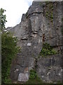
Castle Inn Quarry
A small section of the left hand side of the main climbing wall at the quarry. The Castle inn is now being redeveloped as a private house and the old car park provides a base for climbers to watch others and wait their turn on the numerous sport climbs.
Image: © Paul Glover
Taken: 30 Jul 2011
0.23 miles
8
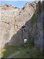
Sport climbing
Castle inn quarry has been developed for sport climbing which means all of the routes have been protected by drilled bolts which the climber clips his rope into as he climbs. Development is so rapid that in the new guidebook this is the last climb in the quarry but there is a whole new wall of climbs to the right behind the old pub which is now being renovated as a private house.
Image: © Paul Glover
Taken: 30 Jul 2011
0.23 miles
9
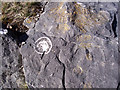
Rock art
Circular colonies of two different lichens on the limestone surface.
Image: © Jonathan Wilkins
Taken: 19 Mar 2008
0.23 miles
10
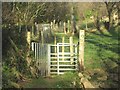
Dwy giat fochyn ar Lwybr y Gogledd / Two kissing gates on the North Wales Path
Image: © Ceri Thomas
Taken: 10 Dec 2011
0.23 miles