IMAGES TAKEN NEAR TO
Eglwysbach, COLWYN BAY, LL28 5RL
Introduction
This page details the photographs taken nearby to LL28 5RL by members of the Geograph project.
The Geograph project started in 2005 with the aim of publishing, organising and preserving representative images for every square kilometre of Great Britain, Ireland and the Isle of Man.

There are currently over 7.5m images from over14,400 individuals and you can help contribute to the project by visiting https://www.geograph.org.uk
Image Map
Images are licensed for reuse under creativecommons.org/licenses/by-sa/2.0
Notes
- Clicking on the map will re-center to the selected point.
- The higher the marker number, the further away the image location is from the centre of the postcode.
Image Listing (7 Images Found)
Images are licensed for reuse under creativecommons.org/licenses/by-sa/2.0
Image
Details
Distance
1
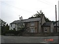
Cottages at Brymbo
Stone cottages in the village of Brymbo in the Conwy Valley
Image: © Dot Potter
Taken: 9 Sep 2005
0.06 miles
2
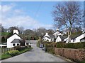
Graig
Small hamlet of cottages near to the Afon Conwy
Image: © Dot Potter
Taken: 19 Apr 2006
0.06 miles

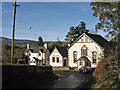
5
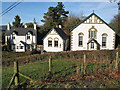
Peniel Chapel
The chapel, schoolhouse and adjacent dwelling viewed from the field across the road. The stone above the window is inscribed simply "PENIEL 1888".
Image: © Jonathan Wilkins
Taken: 4 Jan 2013
0.24 miles
6
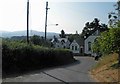
Peniel Chapel 2
Putting the chapel into the context of the landscape, with the very steep Ffordd Cae Forys turning a hairpin bend as it descends to Graig and the distant slope of Tal y Fan on the opposite side of the Conwy Valley.
Image: © Jonathan Wilkins
Taken: 4 Jan 2013
0.24 miles
7
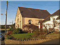
Capel Bryn Seion
The Welsh Baptists' chapel has now been converted to a dwelling with great care and attention to detail. The inscribed stone on the facade reads "ADDOLDY Y BEDYDDWYR, AIL ADEILADWYD 1909" (Baptists' Chapel, rebuilt 1909).
Image: © Jonathan Wilkins
Taken: 4 Jan 2013
0.25 miles