IMAGES TAKEN NEAR TO
Parc Conwy, LLANRWST, LL26 0NE
Introduction
This page details the photographs taken nearby to Parc Conwy, LL26 0NE by members of the Geograph project.
The Geograph project started in 2005 with the aim of publishing, organising and preserving representative images for every square kilometre of Great Britain, Ireland and the Isle of Man.

There are currently over 7.5m images from over14,400 individuals and you can help contribute to the project by visiting https://www.geograph.org.uk
Image Map (Loading...)


Getting Data...Please wait
Leaflet Map data © OpenStreetMap
Images are licensed for reuse under creativecommons.org/licenses/by-sa/2.0
Notes
- Clicking on the map will re-center to the selected point.
- The higher the marker number, the further away the image location is from the centre of the postcode.
Image Listing (123 Images Found)
Images are licensed for reuse under creativecommons.org/licenses/by-sa/2.0
Image
Details
Distance
1
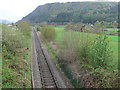
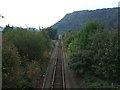
The railway line for Blaenau Ffestiniog
Along the Conwy Valley.
Image: © Eirian Evans
Taken: 30 Apr 2010
0.05 miles
2
One of the last trains
7th September saw the last of the Sunday train services from Llandudno to Blaenau Ffestiniog. Sunday train services will recommence around May 2015.
Image: © Richard Hoare
Taken: 7 Sep 2014
0.05 miles
3
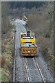
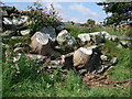
Boulders on their way to shore up the line
These have been taken from a stockpile at Llanrwst North.
The line has been closed since before Christmas and is unlikely to reopen before the end of February.
Image]
For an insight into the works and in particular this stretch of the line see https://www.youtube.com/watch?v=wOBjrQnwku4&app=desktop
Image: © Richard Hoare
Taken: 18 Feb 2016
0.05 miles
4
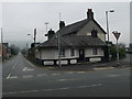
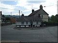
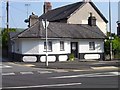
Toll house, Llanrwst
18th century grade 2 listed "Toll House" on the edge of Snowdonia in the picturesque market town of Llanrwst. It is now known as Bryn Amlwg and is a holiday let.
Image: © Eirian Evans
Taken: 18 Feb 2010
0.07 miles
5
Old tree stumps in dry stone wall Llanrwst
Image: © Richard Hoare
Taken: 15 Sep 2009
0.08 miles
6
Railway line to Betws-y-Coed from A470 at Llanrwst
This picturesque line goes from Llandudno Junction to Blaenau Ffestiniog following the Conwy Valley. Standing room only this morning - must be the good weather. For northwards view see
Image]
Image: © Richard Hoare
Taken: 1 Oct 2011
0.08 miles
7
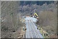
Re-instatement work on the Conwy Valley line
The line has been closed since before Christmas and is unlikely to reopen before the end of February.
Image]
For an insight into the works and in particular this stretch of the line see https://www.youtube.com/watch?v=wOBjrQnwku4&app=desktop
Image: © Richard Hoare
Taken: 18 Feb 2016
0.08 miles
8
An old toll house on A470
Early 19th century toll house now a private dwelling.
Grade II listed - CADW source 3585.
Image: © Richard Hoare
Taken: 1 Oct 2011
0.09 miles
9
Former Tollhouse by the A470 in Llanrwst
Tafarn y Fedw (Brynamlwg) by the A470, in parish of Llanrwst (Conwy District), Tollhouse (Brynamlwg) Borthdy (formerly a ruin by roadside), Ffordd Berth Ddu (Betws Road) junction with Ffordd Cae'r Melwr (Nebo Road) (Lledr Cottage), LL26 0HL.
Grade II listed by Cadw.
Reference Number: 3585 https://cadwpublic-api.azurewebsites.net/reports/listedbuilding/FullReport?lang=&id=3585
To be surveyed
Milestone Society National ID: CON.LRW01
Image: © Milestone Society
Taken: Unknown
0.09 miles
10
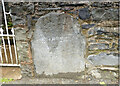
Old Milestone by the B5427, Llanrwst
Stone post in wall by the B5427, in parish of Llanrwst (Conwy County Borough District), Llanrwst, at junction with the A470 in cottage boundary wall, North side of road. Note spelling of Cernioge and Llanrwst.
Weathered inscription reads: TO / Kernioge 10 M / LLanrwſt / Corwen 23
Milestone Society National ID: DEN_LRCN00
Image: © Christopher Leather
Taken: 23 May 2024
0.09 miles