IMAGES TAKEN NEAR TO
Rhyd-y-Foel, ABERGELE, LL22 8EA
Introduction
This page details the photographs taken nearby to LL22 8EA by members of the Geograph project.
The Geograph project started in 2005 with the aim of publishing, organising and preserving representative images for every square kilometre of Great Britain, Ireland and the Isle of Man.

There are currently over 7.5m images from over14,400 individuals and you can help contribute to the project by visiting https://www.geograph.org.uk
Image Map (Loading...)


Getting Data...Please wait
Leaflet Map data © OpenStreetMap
Images are licensed for reuse under creativecommons.org/licenses/by-sa/2.0
Notes
- Clicking on the map will re-center to the selected point.
- The higher the marker number, the further away the image location is from the centre of the postcode.
Image Listing (9 Images Found)
Images are licensed for reuse under creativecommons.org/licenses/by-sa/2.0
Image
Details
Distance
1
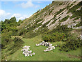
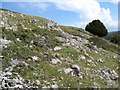
Footpath with rock-art
This footpath leads around the bottom of the scree slopes reaching down from Pen-y-corddyn mawr. The screes may not be natural, but the result of millennia of pecking and scratching at the valuable Carboniferous Limestone outcrop.
Image: © Jonathan Wilkins
Taken: 2 Sep 2008
0.12 miles
2
Disused quarries, Rhyd y Foel
The outcrop of Carboniferous Limestone has been exploited here for a very long time, as indicated by the dark grey colour of the rock faces in the middle distance, and the mature trees covering the heaps of spoil thrown down the hill towards the village.
Image: © Jonathan Wilkins
Taken: 2 Sep 2008
0.14 miles
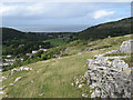
3
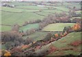
Dulas valley
The Afon Dulas runs through the coastal hills in a deep gorge with cliffs in the Carboniferous Limestone outcrop on both sides. In the middle distance is Craig-y-forwyn Image and in the far distance can be seen Mynydd Marian Image, all summits on the limestone outcrop. It is notable in this view that there is a matching limestone plateau on both sides of the valley at this point.
Image: © Jonathan Wilkins
Taken: 2 Sep 2008
0.17 miles
4
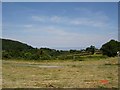
Rhyd Y Foel View
View from the village of Rhyd y Foel towards the coast
Image: © Dot Potter
Taken: 9 Jul 2005
0.20 miles
5
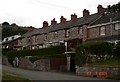
Stone cottages at Rhyd y Foel
A row of stone cottages in the village of Rhyd y Foel near Abergele
Image: © Dot Potter
Taken: 23 Jul 2005
0.20 miles
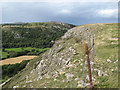
6
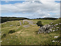
Rampart, Pen-y-corddyn Mawr
Only the northern side of the hillfort is without a natural defence, so a neat pair of ramparts run east to west and define the hilltop stronghold. As there is very little soil up here, the ramparts are built of broken limestone heaped up and looking today very like the lower scree slopes.
Image: © Jonathan Wilkins
Taken: 2 Sep 2008
0.20 miles
8
Miniature forest
The scree, stones and limestone outcrop are covered in part with a low-growing mixture of Blackthorn and Cotoneaster. The large tree is a Yew.
Image: © Jonathan Wilkins
Taken: 2 Sep 2008
0.21 miles
9
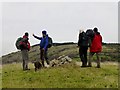
Pen y Corddyn Mawr
I managed to drag the eleven others on Des's celebration walk up this P30 after dragging them through at least one hedge backwards.
Image: © Rude Health
Taken: 24 Nov 2012
0.25 miles