IMAGES TAKEN NEAR TO
Gomer Court, ABERGELE, LL22 7UU
Introduction
This page details the photographs taken nearby to Gomer Court, LL22 7UU by members of the Geograph project.
The Geograph project started in 2005 with the aim of publishing, organising and preserving representative images for every square kilometre of Great Britain, Ireland and the Isle of Man.

There are currently over 7.5m images from over14,400 individuals and you can help contribute to the project by visiting https://www.geograph.org.uk
Image Map
Images are licensed for reuse under creativecommons.org/licenses/by-sa/2.0
Notes
- Clicking on the map will re-center to the selected point.
- The higher the marker number, the further away the image location is from the centre of the postcode.
Image Listing (5 Images Found)
Images are licensed for reuse under creativecommons.org/licenses/by-sa/2.0
Image
Details
Distance
1
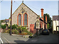
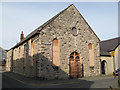
Church House, Croeslwyd
This small building was erected in 1891 as a meeting hall. It is now much disfigured by modern street furniture.
Image: © Jonathan Wilkins
Taken: 15 Aug 2008
0.21 miles
3
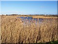
Reed beds
Extensive reed-beds fringe the lake in the park, with the A55 dual-carriageway in the distance. The water and reeds are among the last remnants of the salt-marsh and dune-slacks which pre-dated the modern urbanised coastline.
Image: © Jonathan Wilkins
Taken: 24 Jan 2008
0.22 miles
4
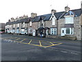
New York Terrace, Abergele
a row of terraced housing on Market Street.
Image: © Eirian Evans
Taken: 6 Dec 2008
0.24 miles
5
Salem Baptist Chapel
A very plain building dating from 1863 in the 'religious' quarter of the town adjacent to Eglwys Crist and close to St. Theresa's. The plain building to the right is an extension containing a schoolroom which was added in the 1930's. Sadly, the building is now disused and boarded-up.
Image: © Jonathan Wilkins
Taken: 15 Aug 2008
0.25 miles