IMAGES TAKEN NEAR TO
King Street, CORWEN, LL21 9SU
Introduction
This page details the photographs taken nearby to King Street, LL21 9SU by members of the Geograph project.
The Geograph project started in 2005 with the aim of publishing, organising and preserving representative images for every square kilometre of Great Britain, Ireland and the Isle of Man.

There are currently over 7.5m images from over14,400 individuals and you can help contribute to the project by visiting https://www.geograph.org.uk
Image Map
Images are licensed for reuse under creativecommons.org/licenses/by-sa/2.0
Notes
- Clicking on the map will re-center to the selected point.
- The higher the marker number, the further away the image location is from the centre of the postcode.
Image Listing (51 Images Found)
Images are licensed for reuse under creativecommons.org/licenses/by-sa/2.0
Image
Details
Distance
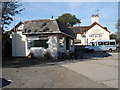
1
Main road through Cerrig-y-Drudion
The village store is on the right
Image: © Eirian Evans
Taken: 10 May 2017
0.01 miles
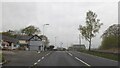
2
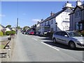
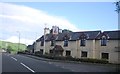
Houses on the old section of the A5 at Cerrigydrudion.
The construction of a by-pass for A5 has brought relative peace and tranquility to the village of Cerrigydrudion, whose name means "stones of the brave".
Image: © Eric Jones
Taken: 9 Jun 2007
0.04 miles
3
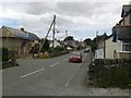
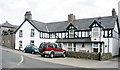
King Street
Looking along King Street in Cerrigydrudion.
Image: © DS Pugh
Taken: 18 Jul 2015
0.04 miles
4
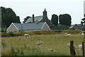
Cerrigydrudion
Chapel & houses viewed from the South
Image: © Chris Shaw
Taken: Unknown
0.04 miles
5
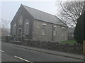
Capel Moriah, Cerrigydrudion
This Congregational chapel in Cerrig was built in 1876. It stands south of the church, on King Street.
Image: © Eirian Evans
Taken: 3 Apr 2009
0.06 miles
6
Old Milestone
Milestone on the A.5 at Cerrigydrudion, Conwy for overall view see http://www.geograph.org.uk/photo/4713584
Image: © Keith Evans
Taken: 24 Oct 2015
0.08 miles
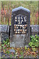
10
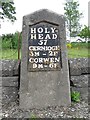
Old Milestone by the A5, Cerrigydrudion
Telford Plate by the A5, in parish of Cerrigydrudion (Conwy County Borough District), in Cerrigydrudion, opposite Saracen's Head PH.
Plate 'Lost' after 2016.
Inscription reads:-
HOLY-
HEAD
57
CERNIOGE
3M - 2F
CORWEN
9M - 6F
Grade II listed by Cadw.
Reference Number: 19340 https://cadwpublic-api.azurewebsites.net/reports/listedbuilding/FullReport?lang=&id=19340
Surveyed
Milestone Society National ID: DEN_HH57
Image: © Milestone Society
Taken: Unknown
0.09 miles