IMAGES TAKEN NEAR TO
Meliden Road, PRESTATYN, LL19 9RT
Introduction
This page details the photographs taken nearby to Meliden Road, LL19 9RT by members of the Geograph project.
The Geograph project started in 2005 with the aim of publishing, organising and preserving representative images for every square kilometre of Great Britain, Ireland and the Isle of Man.

There are currently over 7.5m images from over14,400 individuals and you can help contribute to the project by visiting https://www.geograph.org.uk
Image Map
Images are licensed for reuse under creativecommons.org/licenses/by-sa/2.0
Notes
- Clicking on the map will re-center to the selected point.
- The higher the marker number, the further away the image location is from the centre of the postcode.
Image Listing (51 Images Found)
Images are licensed for reuse under creativecommons.org/licenses/by-sa/2.0
Image
Details
Distance
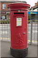
1
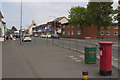
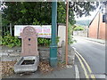
Meliden Road, Prestatyn
A closer view of the postbox can be seen here: Image
Image: © Mark Anderson
Taken: 5 Jun 2013
0.00 miles
2
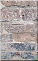
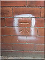
Ordnance Survey Cut Mark
This OS cut mark can be found on the old County Garage Building which is now a coffee bar. It marks a point 22.887m above mean sea level.
Image: © Adrian Dust
Taken: 15 Sep 2019
0.00 miles
4
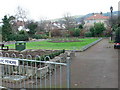
Pendre Gardens, Prestatyn
Pendre Gardens on the corner of Fforddlas and Gronant Road were opened in 1951; a corner of the gardens is dedicated to those men who fell in the two world wards. There is also a tree planted in memory of Diana, Princess of Wales.
Image: © Eirian Evans
Taken: 11 Jan 2008
0.04 miles
5
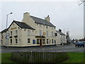
Cross Foxes, Prestatyn
The oldest pub in Prestatyn, having been built in 1664. A close friend of Dr Johnson, Mrs Hester Thrale, stayed there several times in the late 1700's.
Image: © Eirian Evans
Taken: 11 Jan 2008
0.04 miles
6
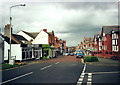
Stryd Fawr Prestatyn High Street
Llwybr Clawdd Offa yn dilyn y Stryd Fawr ym Mhrestatyn.
Offa's Dyke Path following High Street in Prestatyn.
Image: © Alan Richards
Taken: 24 Apr 2000
0.06 miles
7

The top end of Prestatyn High Street
Offa's Dyke Path waymarkers lead walkers from the coast, inland and southwards, gradually uphill through Prestatyn's busy high street shops. Locals are very generous in offering walkers encouragement and advice. One chap with his small kids recommended a pub to me in Bodfari that proved to be a great tip. Thanks to him.
Image: © Jeremy Bolwell
Taken: 27 Aug 2010
0.07 miles
8
Bench mark behind the Cross Foxes P.H. in Fforddlas, Prestatyn
This Ordnance Survey bench mark is cut into the roadside wall of an outbuilding behind the Cross Foxes Public House, Fforddlas, Prestatyn. See also Image
Image: © John S Turner
Taken: 28 Aug 2012
0.07 miles
9
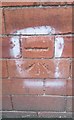
Ordnance Survey Cut Mark
This OS cut mark can be found on the building SW side of Fforddlas. It marks a point 24.509m above mean sea level.
Image: © Adrian Dust
Taken: 15 Sep 2019
0.07 miles
10
Fountain near Parc Pendre
No longer functional, the fountain is dedicated to "loving friends" by two sisters.
Image: © Eirian Evans
Taken: 22 Jul 2020
0.07 miles