IMAGES TAKEN NEAR TO
Mold Road, RUTHIN, LL15 1SL
Introduction
This page details the photographs taken nearby to Mold Road, LL15 1SL by members of the Geograph project.
The Geograph project started in 2005 with the aim of publishing, organising and preserving representative images for every square kilometre of Great Britain, Ireland and the Isle of Man.

There are currently over 7.5m images from over14,400 individuals and you can help contribute to the project by visiting https://www.geograph.org.uk
Image Map
Images are licensed for reuse under creativecommons.org/licenses/by-sa/2.0
Notes
- Clicking on the map will re-center to the selected point.
- The higher the marker number, the further away the image location is from the centre of the postcode.
Image Listing (7 Images Found)
Images are licensed for reuse under creativecommons.org/licenses/by-sa/2.0
Image
Details
Distance
1
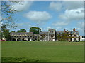
Ruthin School
Gabriel Goodman, Dean of Westminster to Elizabeth I, refounded Ruthin School in 1574 as a centre of academic excellence in North Wales and it was granted a Royal Charter
Image: © David Medcalf
Taken: 23 May 2005
0.08 miles
2
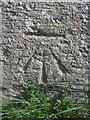
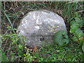
Bench mark on Penrhos Farm gatepost
This Ordnance Survey bench mark is cut into the Penrhos Farm gatepost alongside the A494 Ruthin to Mold Road. See also Image
Image: © John S Turner
Taken: 18 Sep 2018
0.10 miles
3
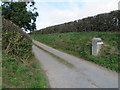
Entrance to Penrhos Farm from the A494
The stone gatepost at the private entrance to Penrhos Farm has an Ordnance Survey bench mark - Image
Image: © John S Turner
Taken: 18 Sep 2018
0.10 miles
4
Milestone on the A494, east of Ruthin
This old and damaged milestone is still marked on modern maps, but is not easy to spot alongside the busy A494. It looks as though it once had a metal plate on the face, which, according to old maps, once read 'Mold 9 Ruthin 1'. The plate may have been removed during the war. See also Image
Image: © John S Turner
Taken: 18 Sep 2018
0.15 miles
5
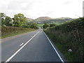
The A494 and a milestone
Looking east along the A494 towards the Clwydian Hills. On the right there is what remains of a milestone, which, according to old maps, once read 'Mold 9 Ruthin 1'. It appears to have lost a metal plate from the face, which may have been removed during the war. Image
Image: © John S Turner
Taken: 18 Sep 2018
0.16 miles