IMAGES TAKEN NEAR TO
Hawthorn Avenue, WREXHAM, LL14 3UE
Introduction
This page details the photographs taken nearby to Hawthorn Avenue, LL14 3UE by members of the Geograph project.
The Geograph project started in 2005 with the aim of publishing, organising and preserving representative images for every square kilometre of Great Britain, Ireland and the Isle of Man.

There are currently over 7.5m images from over14,400 individuals and you can help contribute to the project by visiting https://www.geograph.org.uk
Image Map (Loading...)


Getting Data...Please wait
Leaflet Map data © OpenStreetMap
Images are licensed for reuse under creativecommons.org/licenses/by-sa/2.0
Notes
- Clicking on the map will re-center to the selected point.
- The higher the marker number, the further away the image location is from the centre of the postcode.
Image Listing (21 Images Found)
Images are licensed for reuse under creativecommons.org/licenses/by-sa/2.0
Image
Details
Distance
1
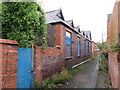
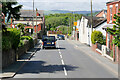
Former Acrefair Drill Hall - east side
Looking along the alley/public footpath on the east side of the former drill hall complex. This interesting single storey building is adjacent to the main hall. Further along the alley there is a row of well-maintained houses that appear to have been built at around the same time - circa 1900.
Image: © John S Turner
Taken: 28 Jul 2014
0.02 miles
2
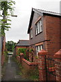
Former Acrefair Drill Hall accommodation house
This fine Ruabon red brick house, which carries the name Swn Aderyn (Bird Noise) is attached to the former drill hall complex and may have been the accommodation house for the Drill Sergeant. See also: Image
Image: © John S Turner
Taken: 28 Jul 2014
0.03 miles
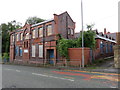
3
Former Acrefair Drill Hall (2)
This once fine Red Ruabon Brick building is alongside Llangollen Road in Acrefair, but the wet weather seems to fit with its current dilapidated state. Not only does it have a glass-roofed main hall running at right angles to the main building, it also has a single storey row of side extensions along the side alley on the far side of the building. In more recent times it was the Maelor Young People's Centre/Canolfan Pobl Ifanc Maelor, but that has now closed as well. See also: Image
Image: © John S Turner
Taken: 28 Jul 2014
0.04 miles
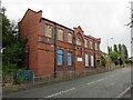
4
Former Acrefair Drill Hall
This once fine Red Ruabon Brick building is alongside Llangollen Road in Acrefair, but the wet weather seems to fit with its current dilapidated state. Not only does it have a glass-roofed main hall running at right angles to the main building, it also has a single storey row of side extensions along the side alley. In more recent times it was the Maelor Young People's Centre/Canolfan Pobl Ifanc Maelor, but that has now closed as well. See also: Image
Image: © John S Turner
Taken: 28 Jul 2014
0.04 miles
6

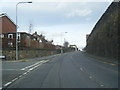
Bethania Road, Acrefair
Bethania Road leads off Llangollen Road. The street name sign looks as though it has seen better days.
Image: © Stephen McKay
Taken: 19 Feb 2019
0.13 miles
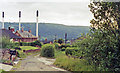
8
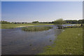
The Deplh
The site of the former Delph clay works. The landscape was changed beyond recognition in the 1970's when an opencast mining company began operations and this small lake appeared.
Image: © Geraint Roberts
Taken: 12 May 2016
0.17 miles
9
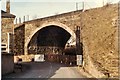
Acrefair Bridge
Taken shortly before demolition, the steps leading up to the railway station, just visible on the right.
Image: © Geraint Roberts
Taken: 25 Feb 1979
0.18 miles
10
Acrefair station (site/remains), 1992
View NW, towards Llangollen and Barmouth: ex-GWR (Chester) - Ruabon - Dolgelley - Barmouth Junction line, closed 18/1/65, but partly restored by the Llangollen Railway since 1975.
Image: © Ben Brooksbank
Taken: 23 Jun 1992
0.19 miles