IMAGES TAKEN NEAR TO
Lloyds Terrace, High Street, WREXHAM, LL14 3BS
Introduction
This page details the photographs taken nearby to Lloyds Terrace, High Street, LL14 3BS by members of the Geograph project.
The Geograph project started in 2005 with the aim of publishing, organising and preserving representative images for every square kilometre of Great Britain, Ireland and the Isle of Man.

There are currently over 7.5m images from over14,400 individuals and you can help contribute to the project by visiting https://www.geograph.org.uk
Image Map (Loading...)


Getting Data...Please wait
Leaflet Map data © OpenStreetMap
Images are licensed for reuse under creativecommons.org/licenses/by-sa/2.0
Notes
- Clicking on the map will re-center to the selected point.
- The higher the marker number, the further away the image location is from the centre of the postcode.
Image Listing (21 Images Found)
Images are licensed for reuse under creativecommons.org/licenses/by-sa/2.0
Image
Details
Distance
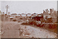
1
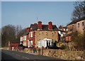
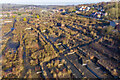
Houses on Stryd y Brenin
In the last few years the view from King Street has improved with the removal of the old phenol works (now Flexsys). Image]
Image: © John Haynes
Taken: 24 Mar 2012
0.06 miles
2
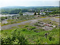
The brown field site that was Monsanto Chemicals
Completely demolished the chemical works that was a major local employer from the 1880's until the 2000's is no more. Nature is working hard to reclaim its own, but concerns over contamination still linger.
Image]
Image]
Image]
Image: © John Haynes
Taken: 27 May 2016
0.14 miles
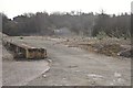
3
Massive brown field site
This site has produced various chemicals since the 1860's and the current plant producing rubber production chemicals is being wound down. What this site will be used for is at present unknown.
Image]
Image]
Image]
Image: © John Haynes
Taken: 26 Mar 2012
0.15 miles
4
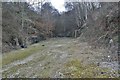
Acrefair Station old track bed
Looking towards the Ruabon end through the cut. The iron foot bridge from Cae Coch to Coed Richard is just visible through the trees.
Image: © Geraint Roberts
Taken: 24 Feb 2012
0.16 miles
5
Acrefair station
Acrefair station before demolition taken in 1973.
Image: © Geraint Roberts
Taken: 18 Mar 1973
0.16 miles
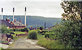
6
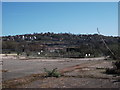
Approximate site of old Acrefair Station
Taken in March 2012,looking towards the Ruabon end of the line, Cae Coch visible behind the trees. This is the former Air Products site awaiting redevelopment.
Image: © Geraint Roberts
Taken: 2 Mar 2012
0.17 miles
7
Acrefair station (site/remains), 1992
View NW, towards Llangollen and Barmouth: ex-GWR (Chester) - Ruabon - Dolgelley - Barmouth Junction line, closed 18/1/65, but partly restored by the Llangollen Railway since 1975.
Image: © Ben Brooksbank
Taken: 23 Jun 1992
0.18 miles
9
Brownfield land at former Cefn Mawr Monsanto Works
The chemical factory closed in the late 2000s and was subsequently demolished in 2010. Nature is starting to take over in the decade since, but concerns about contamination linger.
See also Image
Image: © Andrew Abbott
Taken: 19 Jan 2020
0.21 miles
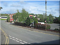
10
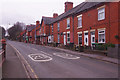
Llangollen Road, Acrefair
This is a stretch of the A539 as it passes through the workaday village of Acrefair - lined here with solid-looking red brick terraced houses.
Image: © Stephen McKay
Taken: 19 Feb 2019
0.22 miles