IMAGES TAKEN NEAR TO
Middle Sontley, WREXHAM, LL13 0YP
Introduction
This page details the photographs taken nearby to LL13 0YP by members of the Geograph project.
The Geograph project started in 2005 with the aim of publishing, organising and preserving representative images for every square kilometre of Great Britain, Ireland and the Isle of Man.

There are currently over 7.5m images from over14,400 individuals and you can help contribute to the project by visiting https://www.geograph.org.uk
Image Map
Images are licensed for reuse under creativecommons.org/licenses/by-sa/2.0
Notes
- Clicking on the map will re-center to the selected point.
- The higher the marker number, the further away the image location is from the centre of the postcode.
Image Listing (8 Images Found)
Images are licensed for reuse under creativecommons.org/licenses/by-sa/2.0
Image
Details
Distance
1
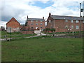
Gentrification of the steading at Middle Sontley
The steading is polishing up well.
Image: © John Haynes
Taken: 8 May 2012
0.02 miles
3
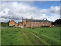
Wat's Dyke Way and Middle Sontley Farm
Looking north along Wat's Dyke Way towards Middle Sontley Farm. There is an Ordnance Survey benchmark on the left of the nearest building: Image
Image: © John S Turner
Taken: 7 Aug 2018
0.03 miles
4
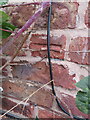
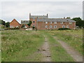
Benchmark on Middle Sontley Farm barn conversion
Ordnance Survey benchmark on Middle Sontley Farm barn conversion. Wat's Dyke Way passes the farm via a minor road. For a view of the farm see: Image Benchmark database: https://www.bench-marks.org.uk/bm197140
Image: © John S Turner
Taken: 7 Aug 2018
0.03 miles
5
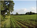
Maize crop beside Wat's Dyke
Rows of maize growing alongside the public footpath adjoining Wat's Dyke which lies to the left of the shot.
Image: © Ian Paterson
Taken: 28 Jun 2011
0.05 miles
6
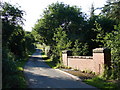
Bridge over Black Brook
Road bridge on the western approach to Middle Sontley.
Image: © Ian Paterson
Taken: 28 Jun 2011
0.14 miles
7
Path of tramway away from the clay pit
The tramway was steam powered from the start and there is plenty of evidence of tramways leading to the Ruabon works.
Image: © John Haynes
Taken: 8 May 2012
0.24 miles
8
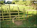
Stile on the footpath near Wat's Dyke
Leading into the sunshine and Wat's Dyke which lies in the trees to the right.
Image: © Ian Paterson
Taken: 28 Jun 2011
0.25 miles