IMAGES TAKEN NEAR TO
Ty Cerrig, WREXHAM, LL12 9LF
Introduction
This page details the photographs taken nearby to Ty Cerrig, LL12 9LF by members of the Geograph project.
The Geograph project started in 2005 with the aim of publishing, organising and preserving representative images for every square kilometre of Great Britain, Ireland and the Isle of Man.

There are currently over 7.5m images from over14,400 individuals and you can help contribute to the project by visiting https://www.geograph.org.uk
Image Map
Images are licensed for reuse under creativecommons.org/licenses/by-sa/2.0
Notes
- Clicking on the map will re-center to the selected point.
- The higher the marker number, the further away the image location is from the centre of the postcode.
Image Listing (141 Images Found)
Images are licensed for reuse under creativecommons.org/licenses/by-sa/2.0
Image
Details
Distance
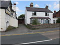
1

No parking in Ty Cerrig, Caergwrle, Flintshire
Double yellow lines on both sides of the narrow street named Ty Cerrig indicate no parking at any time.
Image: © Jaggery
Taken: 29 Jan 2018
0.02 miles
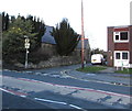
2
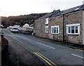
Bryn Yorkin, Caergwrle, Flintshire
A view to the southwest from High Street along the road named Bryn Yorkin.
Image: © Jaggery
Taken: 29 Jan 2018
0.03 miles
3
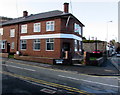
Former HSBC bank branch, Caergwrle, Flintshire
On the corner of High Street and Ty Cerrig, viewed in January 2018.
The branch closed down in December 2016. Accounts held here were transferred to HSBC Wrexham.
Image: © Jaggery
Taken: 29 Jan 2018
0.04 miles
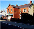
4
Ty Cerrig residential care home, Caergwrle, Flintshire
At 27 High Street, on the corner of the street named Ty Cerrig.
Image: © Jaggery
Taken: 29 Jan 2018
0.05 miles
5
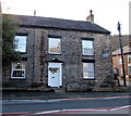
Caergwrle Drill Hall in High Street
The white house in the centre of the photo, and the long roof just visible beyond the garage, were built prior to 1899 as Caergwrle Drill Hall with accommodation. However, the garage wasn't built until after the 1912 O.S. map. In 2014 the house and garage were up for sale, whilst the drill hall behind is now Caergwrle Social Club. The brick walls and roof of the social club all look modern so it is unknown how much, if any, of the original hall is left. See also Image
Image: © John S Turner
Taken: 23 Jul 2014
0.06 miles
6
Formerly Caergwrle Drill Hall
The white house in the centre of the photo, and the long social club room behind, were built prior to 1899 as Caergwrle Drill Hall with accommodation. In 2014 the house and its garage were up for sale, whilst the drill hall behind is now Caergwrle Social Club. The brick walls and roof of the social club all look modern so it is unknown how much, if any, of the original hall is left. See also: Image
Image: © John S Turner
Taken: 23 Jul 2014
0.06 miles
7
Castle Pharmacy, 38 High Street, Caergwrle, Flintshire
Viewed in January 2018. A March 2011 Google Earth Street View show Westminster Park Pharmacy here.
Image: © Jaggery
Taken: 29 Jan 2018
0.06 miles
8
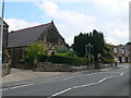
Caergwrle Presbyterian Church
On the High Street in Caergwrle.
Image: © Eirian Evans
Taken: 10 Jun 2009
0.06 miles
9
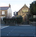
South side of Caergwrle Presbyterian Chapel, Flintshire
The High Street side of the chapel on the corner of Fellows Lane in Caergwrle.
This is the 1845 rebuild of the original chapel erected in 1809.
Image: © Jaggery
Taken: 29 Jan 2018
0.06 miles
10
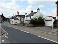
Junction of High Street and Fellows Lane, Caergwrle, Flintshire
Viewed across the A541 High Street from the corner of Bryn Yorkin.
Caergwrle Presbyterian Chapel https://www.geograph.org.uk/photo/5819246 is on the left. Tegfan Court https://www.geograph.org.uk/photo/5819168 is on the right.
Image: © Jaggery
Taken: 29 Jan 2018
0.06 miles