IMAGES TAKEN NEAR TO
Fellows Lane, WREXHAM, LL12 9AL
Introduction
This page details the photographs taken nearby to Fellows Lane, LL12 9AL by members of the Geograph project.
The Geograph project started in 2005 with the aim of publishing, organising and preserving representative images for every square kilometre of Great Britain, Ireland and the Isle of Man.

There are currently over 7.5m images from over14,400 individuals and you can help contribute to the project by visiting https://www.geograph.org.uk
Image Map
Images are licensed for reuse under creativecommons.org/licenses/by-sa/2.0
Notes
- Clicking on the map will re-center to the selected point.
- The higher the marker number, the further away the image location is from the centre of the postcode.
Image Listing (156 Images Found)
Images are licensed for reuse under creativecommons.org/licenses/by-sa/2.0
Image
Details
Distance
1
Signposts for the Wales Link Path
Designated in 2017, the Wales Link Path is a 29 km long path connecting the north-east end of the Wales Coastal Path with Offa's Dyke Path near Llandegla. Seen here on Derby Road, Caergwrle.
Image: © Oliver Dixon
Taken: 30 Jun 2021
0.01 miles
2
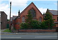
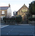
Disused chapel on the High Street in Caergwrle
Image: © Eirian Evans
Taken: 10 Jun 2009
0.03 miles
3
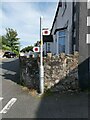
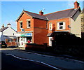
Junction of High Street and Fellows Lane, Caergwrle, Flintshire
Viewed across the A541 High Street from the corner of Bryn Yorkin.
Caergwrle Presbyterian Chapel https://www.geograph.org.uk/photo/5819246 is on the left. Tegfan Court https://www.geograph.org.uk/photo/5819168 is on the right.
Image: © Jaggery
Taken: 29 Jan 2018
0.03 miles
4
Caergwrle Presbyterian Church
On the High Street in Caergwrle.
Image: © Eirian Evans
Taken: 10 Jun 2009
0.03 miles
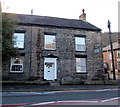
5
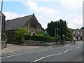
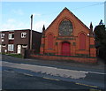
South side of Caergwrle Presbyterian Chapel, Flintshire
The High Street side of the chapel on the corner of Fellows Lane in Caergwrle.
This is the 1845 rebuild of the original chapel erected in 1809.
Image: © Jaggery
Taken: 29 Jan 2018
0.03 miles
6
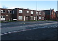
Tegfan Court, Caergwrle, Flintshire
High Street side of flats on the corner of Fellows Lane.
Image: © Jaggery
Taken: 29 Jan 2018
0.03 miles
7
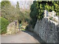
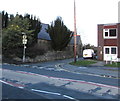
Fellows Lane, Caergwrle
The top of Fellows Lane where it meets Derby Road in Caergwrle. This lane drops down to cross the ancient packhorse bridge and then continues to meet the A550 between Caergwrle and Hope.
Image: © John S Turner
Taken: 25 Mar 2007
0.04 miles
8
Former Methodist Chapel, High Street, Caergwrle, Flintshire
The foundation stones show the year 1899. In January 2018, Caergwrle's Methodist Church is in Castle Street. https://www.geograph.org.uk/photo/5665720
Image: © Jaggery
Taken: 29 Jan 2018
0.04 miles
9
Castle Pharmacy, 38 High Street, Caergwrle, Flintshire
Viewed in January 2018. A March 2011 Google Earth Street View show Westminster Park Pharmacy here.
Image: © Jaggery
Taken: 29 Jan 2018
0.04 miles
10
Ty Cerrig residential care home, Caergwrle, Flintshire
At 27 High Street, on the corner of the street named Ty Cerrig.
Image: © Jaggery
Taken: 29 Jan 2018
0.04 miles