IMAGES TAKEN NEAR TO
Sarn Lane, WREXHAM, LL12 9AG
Introduction
This page details the photographs taken nearby to Sarn Lane, LL12 9AG by members of the Geograph project.
The Geograph project started in 2005 with the aim of publishing, organising and preserving representative images for every square kilometre of Great Britain, Ireland and the Isle of Man.

There are currently over 7.5m images from over14,400 individuals and you can help contribute to the project by visiting https://www.geograph.org.uk
Image Map (Loading...)


Getting Data...Please wait
Leaflet Map data © OpenStreetMap
Images are licensed for reuse under creativecommons.org/licenses/by-sa/2.0
Notes
- Clicking on the map will re-center to the selected point.
- The higher the marker number, the further away the image location is from the centre of the postcode.
Image Listing (107 Images Found)
Images are licensed for reuse under creativecommons.org/licenses/by-sa/2.0
Image
Details
Distance
1
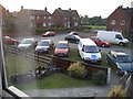
Sarn Lane, Caergwrle (Not Hope) LL12
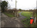
Sarn Lane, Caergwrle. The road that leads to Hope turning from a road to a meadow footpath and a little bridge across the river to Hope (not the Packhorse Bridge).
Image: © Graeme Walker
Taken: 3 Jul 2006
0.03 miles
2
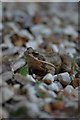
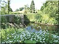
Frog
Found in the back garden next to the River Alyn.
Image: © Graeme Walker
Taken: 25 Apr 2007
0.05 miles
3
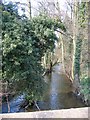
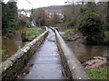
The Millrace from Caergwrle's Packhorse Bridge
The 1879 O.S. map records this channel as a millrace, although there is no sign of a mill on the map or on the ground. The channel for the River Alyn/Afon Alun is a few metres to the left. Viewed from the ancient packhorse bridge.
Image: © John S Turner
Taken: 25 Mar 2007
0.10 miles
4
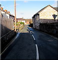
Hope Street, Caergwrle, Flintshire
From High Street along Hope Street towards Derby Road and Sarn Lane.
Image: © Jaggery
Taken: 29 Jan 2018
0.11 miles
5
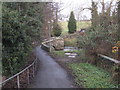
Footpath from Sarn Lane
Here Sarn Lane follows the square field boundary whilst this footpath takes the direct line across the corner. The name of the lane suggests that there was a Roman road nearby, but if so it would not have had a right-angled corner. The tower of Hope church can be seen in the far distance.
Image: © John S Turner
Taken: 13 Dec 2009
0.11 miles
6
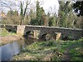
Caergwrle's Packhorse Bridge
Looking at the ancient packhorse bridge from alongside the River Alyn/Avon Alun. The additional arches, which appear to be redundant, allow excess water to pass under the bridge at times of flood. The bridge was badly damaged by floods in November 2000 and was restored in 2001.
Image: © John S Turner
Taken: 25 Mar 2007
0.11 miles
7
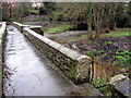
Small gate on Caergwrle's Packhorse Bridge/Y Bont Pynfarch
The small gate on the right once provided access to the island between the two river channels and the sluice gates that controlled the flow of water to the riverside mills. See also Image
Image: © John S Turner
Taken: 7 Dec 2009
0.11 miles
8
Pack horse bridge over the River Alyn
Pack horse bridge over the River Alyn
16th century bridge on a path linking Caergwrle and Hope. The low parapets allowed for wide loads and panniers carried by pack animals to overhang the river, whilst the triangular refuge allowed pedestrians to make way for the passage of pack animals.
Image: © Oliver Dixon
Taken: 30 Jun 2021
0.11 miles
9
Caergwrle's Packhorse Bridge/Y Bont Pynfarch
Looking across the historic packhorse bridge at Caergwrle. The recent high water has subsided but there is still a strong flow of water through the multiple arches. At the first kink in the bridge there is a set of steps on the right, down to the island between the two river channels; this was to provide access to the sluice gates that once controlled the flow of water to the riverside mills.
Image: © John S Turner
Taken: 7 Dec 2009
0.11 miles
10
Caergwrle's Packhorse Bridge/Y Bont Pynfarch
Looking along Fellows Lane towards the historic packhorse bridge.
Image: © John S Turner
Taken: 13 Dec 2009
0.12 miles