IMAGES TAKEN NEAR TO
Mill Road, LEICESTER, LE7 4YN
Introduction
This page details the photographs taken nearby to Mill Road, LE7 4YN by members of the Geograph project.
The Geograph project started in 2005 with the aim of publishing, organising and preserving representative images for every square kilometre of Great Britain, Ireland and the Isle of Man.

There are currently over 7.5m images from over14,400 individuals and you can help contribute to the project by visiting https://www.geograph.org.uk
Image Map
Images are licensed for reuse under creativecommons.org/licenses/by-sa/2.0
Notes
- Clicking on the map will re-center to the selected point.
- The higher the marker number, the further away the image location is from the centre of the postcode.
Image Listing (106 Images Found)
Images are licensed for reuse under creativecommons.org/licenses/by-sa/2.0
Image
Details
Distance
1
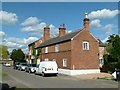
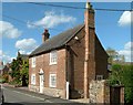
30 and 32 Mill Road
Built in 1743 as a single unit but apparently always a pair of separate dwellings.
The original building was the lower section, originally a single storey building, the upper floor being added in the 19th century. No.30 is nearest the camera; no.32 originally comprised the part beyond the central chimney stack, and has a datestone inscribed 1743. To this was added the higher part of the building sometime in the 19th century. Listed Grade II as a single unit.
Image: © Alan Murray-Rust
Taken: 28 Apr 2015
0.01 miles
2
32 Mill Road, Rearsby
The oldest part is dated 1743 https://historicengland.org.uk/listing/the-list/list-entry/1307355?section=official-list-entry
Image: © Jonathan Thacker
Taken: 5 Mar 2022
0.02 miles
3
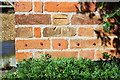
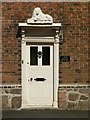
Benchmark on #35 Mill Road
Ordnance Survey cut mark benchmark described on the Bench Mark Database at www.bench-marks.org.uk/bm89195
Image: © Roger Templeman
Taken: 11 Sep 2017
0.02 miles
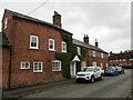
4
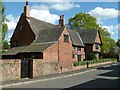
Nos. 35 and 37 Mill Road
There is an Ordnance Survey benchmark Image on the corner, right hand face, of the nearer house, right of its brown door
Image: © Roger Templeman
Taken: 11 Sep 2017
0.02 miles
5
12 Mill Road, Rearsby, Lion House
18th century brick house, the current name deriving from the carved lion over the main entrance http://www.geograph.org.uk/photo/4461236. The front eaves level was raised in the 19th century, the rear roof maintaining the original slope. Listed Grade II.
Image: © Alan Murray-Rust
Taken: 28 Apr 2015
0.03 miles
6

Lion House, Rearsby
A former public house with brewhouse at the rear https://historicengland.org.uk/listing/the-list/list-entry/1074487?section=official-list-entry
Image: © Jonathan Thacker
Taken: 5 Mar 2022
0.03 miles
7
Doorway, Lion House, Mill Road Rearsby
Doorway, Lion House, Mill Street Rearsby
Image: © Alan Murray-Rust
Taken: 28 Apr 2015
0.03 miles
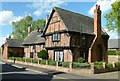
8
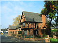
The Olde House, Mill Road, Rearsby
Built as a yeoman's manor house and dated 1610 and 1613. Timber framed structure with brick infill panels, largely in herringbone style. The roof is formed from graduated Swithland slates. The house was substantially restored in 1935 after being purchased by Sir Frank Craven. The restoration included the replacement of wattle and daub infill of the framing with the present brickwork; the bricks themselves are not of standard dimensions and could well be older reused bricks. The jutting wing at this end of the house is from this period as well. Listed Grade II.
Image: © Alan Murray-Rust
Taken: 28 Apr 2015
0.04 miles
9
The Olde House, Mill Road, Rearsby
Grade II listed; dating from the early 17th Century
Image: © Tim Heaton
Taken: 14 Oct 2007
0.05 miles
10
The Olde House, Road, Rearsby
Built as a yeoman's manor house and dated 1610 and 1613. Timber framed structure with brick infill panels, largely in herringbone style. The roof is formed from graduated Swithland slates.
The house was substantially restored in 1935 after being purchased by Sir Frank Craven. The restoration included the replacement of wattle and daub infill of the framing with the present brickwork; the bricks themselves are not of standard dimensions and could well be older reused bricks. Listed Grade II.
Image: © Alan Murray-Rust
Taken: 28 Apr 2015
0.05 miles