IMAGES TAKEN NEAR TO
Fosse Way, LEICESTER, LE7 4SJ
Introduction
This page details the photographs taken nearby to Fosse Way, LE7 4SJ by members of the Geograph project.
The Geograph project started in 2005 with the aim of publishing, organising and preserving representative images for every square kilometre of Great Britain, Ireland and the Isle of Man.

There are currently over 7.5m images from over14,400 individuals and you can help contribute to the project by visiting https://www.geograph.org.uk
Image Map
Images are licensed for reuse under creativecommons.org/licenses/by-sa/2.0
Notes
- Clicking on the map will re-center to the selected point.
- The higher the marker number, the further away the image location is from the centre of the postcode.
Image Listing (6 Images Found)
Images are licensed for reuse under creativecommons.org/licenses/by-sa/2.0
Image
Details
Distance
1
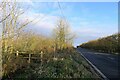
The Leicestershire Round crossing the north-bound carriageway of the A46
Nasty crossing of the old Roman Road, the Fosse Way
Image: © Tim Heaton
Taken: 2 Dec 2021
0.09 miles
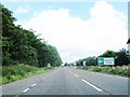
2
A46 towards Ratcliffe on The Wreake
Junction half a mile ahead.
Image: © J.Hannan-Briggs
Taken: 18 Jul 2015
0.10 miles
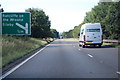
3
South along the A46
The skyline of Leicester city centre is visible about seven miles distant.
Image: © Mat Fascione
Taken: 15 Jun 2008
0.10 miles
4
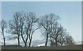
The Leicestershire Round crosses fields towards the A46
Image: © Tim Glover
Taken: 27 Dec 1994
0.21 miles
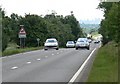
5
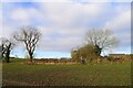
On the Leicestershire Round, approaching Longlands Farm
After climbing up from the Wreake valley
Image: © Tim Heaton
Taken: 2 Dec 2021
0.22 miles