IMAGES TAKEN NEAR TO
Farriers Way, LEICESTER, LE7 3ZE
Introduction
This page details the photographs taken nearby to Farriers Way, LE7 3ZE by members of the Geograph project.
The Geograph project started in 2005 with the aim of publishing, organising and preserving representative images for every square kilometre of Great Britain, Ireland and the Isle of Man.

There are currently over 7.5m images from over14,400 individuals and you can help contribute to the project by visiting https://www.geograph.org.uk
Image Map
Images are licensed for reuse under creativecommons.org/licenses/by-sa/2.0
Notes
- Clicking on the map will re-center to the selected point.
- The higher the marker number, the further away the image location is from the centre of the postcode.
Image Listing (36 Images Found)
Images are licensed for reuse under creativecommons.org/licenses/by-sa/2.0
Image
Details
Distance
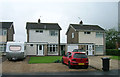
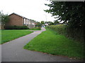
2
No. 48 Long Furrow at Ploughman's Lea junction
There is an Ordnance Survey benchmark Image above the hydrant sign
Image: © phil Richards
Taken: 21 Sep 2017
0.06 miles
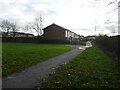
3
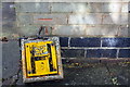
Benchmark and broken hydrant sign at No. 48 Long Furrow
Ordnance Survey cut mark benchmark described on the Bench Mark Database at www.bench-marks.org.uk/bm89531
Image: © phil Richards
Taken: 21 Sep 2017
0.06 miles
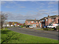
5
East Goscote, Leicestershire
With a population of approximately 3000, East Goscote is a 'new' village, complete with school, church and village shops. It was built to the west of the A607 in the 1960s as an overflow residential area for Leicester, which is 6 miles to the south.
Image: © Kate Jewell
Taken: 6 Sep 2005
0.11 miles
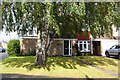
8

St Hilda's Church, East Goscote
This 1960's church blends in with the typical architecture of the village.
Image: © Kate Jewell
Taken: 6 Sep 2005
0.16 miles
9

St Hilda's church, East Goscote
Built in 1976.
Image: © Jonathan Thacker
Taken: 29 Dec 2024
0.17 miles
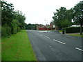
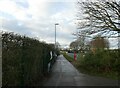
10
Long Furrow, East Goscote
This is the main distributor road for the village, completing a circuit of most of the housing development.
Image: © Alan Murray-Rust
Taken: 22 Nov 2013
0.18 miles