IMAGES TAKEN NEAR TO
Countrymans Way, LEICESTER, LE7 3WU
Introduction
This page details the photographs taken nearby to Countrymans Way, LE7 3WU by members of the Geograph project.
The Geograph project started in 2005 with the aim of publishing, organising and preserving representative images for every square kilometre of Great Britain, Ireland and the Isle of Man.

There are currently over 7.5m images from over14,400 individuals and you can help contribute to the project by visiting https://www.geograph.org.uk
Image Map
Images are licensed for reuse under creativecommons.org/licenses/by-sa/2.0
Notes
- Clicking on the map will re-center to the selected point.
- The higher the marker number, the further away the image location is from the centre of the postcode.
Image Listing (22 Images Found)
Images are licensed for reuse under creativecommons.org/licenses/by-sa/2.0
Image
Details
Distance
1
East Goscote from the 'hill'
East Goscote was built as a new village on the site of a wartime Royal Ordnance Factory. Decommissioned in 1959 the factory site was developed from 1962 as a complete community of around 3000 residents with schools, shops, churches and industrial units.
Many of the concrete tunnels from the wartime construction exist, although all entrances are concealed by landscaping. The 'hill' from which this view is taken is an artificial mound concealing two shell storage bunkers which were too massive to be demolished.
Image: © Alan Murray-Rust
Taken: 22 Nov 2013
0.02 miles
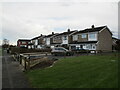
2
East Goscote recreation ground
The 'hill' from which this view is taken is an artificial mound created to cover the two massive shell bunkers left from the time when this area was a Royal Ordnance Depot.
Image: © Alan Murray-Rust
Taken: 22 Nov 2013
0.10 miles
3

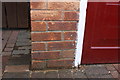
Benchmark on house at bend in Broome Lane
Ordnance Survey cut mark benchmark described on the Bench Mark Database at www.bench-marks.org.uk/bm89527
Image: © Roger Templeman
Taken: 11 Sep 2017
0.13 miles
4
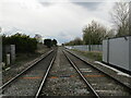
Railway towards Leicester
Seen from Broome Lane level crossing.
Image: © Jonathan Thacker
Taken: 8 Apr 2022
0.13 miles
5
Benchmark on garage of #138 Long Furrow
Ordnance Survey cut mark benchmark described on the Bench Mark Database at www.bench-marks.org.uk/bm89529
Image: © Roger Templeman
Taken: 11 Sep 2017
0.14 miles
6
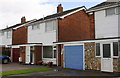
Nos. 138 and 136 Long Furrow
There is an Ordnance Survey benchmark Image on the bricks on the left hand side of the brown garage door near the left hand edge of the image
Image: © Roger Templeman
Taken: 11 Sep 2017
0.14 miles
7
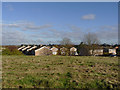
Houses on Broome Lane, East Goscote
Image: © Jonathan Thacker
Taken: 8 Apr 2022
0.14 miles
8
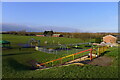
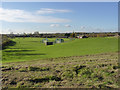
Playground and field, East Goscote
Flat ground on the Wreake floodplain
Image: © Tim Heaton
Taken: 1 Feb 2021
0.14 miles
9
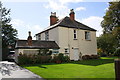
'Broomleigh', Broome Lane
There is an Ordnance Survey benchmark Image on the near left hand corner (facing the drive) of the single storey extension of the house
Image: © Roger Templeman
Taken: 11 Sep 2017
0.14 miles
10
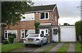
No.172 Broome Lane
There is an Ordnance Survey benchmark Image in the bricks of the garage between its door and side door
Image: © phil Richards
Taken: 21 Sep 2017
0.14 miles