IMAGES TAKEN NEAR TO
Main Street, LEICESTER, LE7 3BL
Introduction
This page details the photographs taken nearby to Main Street, LE7 3BL by members of the Geograph project.
The Geograph project started in 2005 with the aim of publishing, organising and preserving representative images for every square kilometre of Great Britain, Ireland and the Isle of Man.

There are currently over 7.5m images from over14,400 individuals and you can help contribute to the project by visiting https://www.geograph.org.uk
Image Map
Images are licensed for reuse under creativecommons.org/licenses/by-sa/2.0
Notes
- Clicking on the map will re-center to the selected point.
- The higher the marker number, the further away the image location is from the centre of the postcode.
Image Listing (67 Images Found)
Images are licensed for reuse under creativecommons.org/licenses/by-sa/2.0
Image
Details
Distance
1
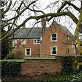
Brooke House Farmhouse, Beeby
A composite of various periods, the windows in particular appearing to be 19th century re-fittings. The south wing (not visible in this picture) is dated 1722, but parts of the house are older. Listed Grade II.
Image: © Alan Murray-Rust
Taken: 23 Mar 2018
0.01 miles
2
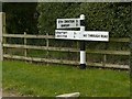
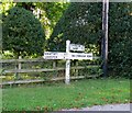
Fingerpost at Beeby
Traditional Leicestershire style with concrete post. Good to see that it has been thoroughly re-furbished since 2011 https://www.geograph.org.uk/photo/2652836
Image: © Alan Murray-Rust
Taken: 23 Mar 2018
0.04 miles
5
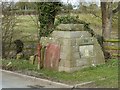
Beeby well and pump
The well-head was built in 1855 to cover an established spring, and has an amusing inscription on the side http://www.geograph.org.uk/photo/5719019 . There is also a plaque recording the restoration of the well-head at the time of the coronation in 1953. The pump is of uncertain and manufacture. Listed Grade II, the listing refers to a surrounding rail, of which some of the supporting posts are visible, although the rail has disappeared, possibly due to the need to accommodate modern farm vehicles on a narrow road!
Image: © Alan Murray-Rust
Taken: 23 Mar 2018
0.05 miles
6
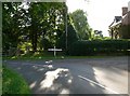
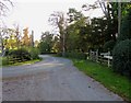
Main Street in Beeby
Its junction with Croxton Road.
Image: © Mat Fascione
Taken: 16 Jul 2007
0.05 miles
7
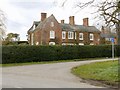
Manor House, Beeby
Dating largely from the late 18th century. Listed Grade II.
Image: © Alan Murray-Rust
Taken: 23 Mar 2018
0.05 miles
8
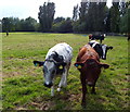
Cattle in a small field in Beeby
This field is along the Main Street, opposite All Saints church.
Image: © Mat Fascione
Taken: 5 Jul 2014
0.05 miles
9
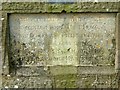
Inscription at Beeby well
See http://www.geograph.org.uk/photo/5719014 for location.
Image: © Alan Murray-Rust
Taken: 23 Mar 2018
0.05 miles
10
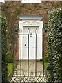
Doorway to The Manor House, Beeby
The Listing dates this to c.1740, and therefore older than much of the fabric of the house, and not in its original position. See http://www.geograph.org.uk/photo/5719994 for location.
Image: © Alan Murray-Rust
Taken: 23 Mar 2018
0.06 miles