IMAGES TAKEN NEAR TO
Red Hill Lane, COALVILLE, LE67 8NL
Introduction
This page details the photographs taken nearby to Red Hill Lane, LE67 8NL by members of the Geograph project.
The Geograph project started in 2005 with the aim of publishing, organising and preserving representative images for every square kilometre of Great Britain, Ireland and the Isle of Man.

There are currently over 7.5m images from over14,400 individuals and you can help contribute to the project by visiting https://www.geograph.org.uk
Image Map
Images are licensed for reuse under creativecommons.org/licenses/by-sa/2.0
Notes
- Clicking on the map will re-center to the selected point.
- The higher the marker number, the further away the image location is from the centre of the postcode.
Image Listing (18 Images Found)
Images are licensed for reuse under creativecommons.org/licenses/by-sa/2.0
Image
Details
Distance
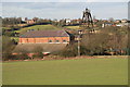
1
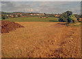
The Ivanhoe Way at Red Hill
From the Ivanhoe Way looking east towards Whitwick. Small herd of bullocks in the next field and a large pile of dung on the left waits to be spread on the recently harvested field. This long distance path covers a 35-mile circular route around North Leicestershire.
http://www.leics.gov.uk/index/environment/countryside/walking/ivanhoeway.htm
Image: © Trevor Rickard
Taken: 29 Aug 2009
0.08 miles
2
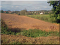
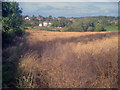
Farmland west of Thringstone
From the Ivanhoe Way looking north-east towards Thringstone. Mixed arable and grassland in this area.
Image: © Trevor Rickard
Taken: 29 Aug 2009
0.12 miles
3
Calcutta Pit
The Calcutta pumping engine installed here in 1877 was made by Robert Stephenson and Co. at a cost of £13,000. It was capable of removing 54,000 gallons an hour to keep local mines dry and worked until 1947. The engine house is a listed building.
Image]
Image: © Ashley Dace
Taken: 21 May 2012
0.18 miles
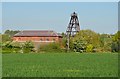
4
Calcutta Pit headgear and engine house
Looking north from the Ivanhoe Way to Calcutta Pit headgear and engine house - see Image and Image The Calcutta pumping engine installed here in 1877 was made by Robert Stephenson and Co. at a cost of £13,000. It was capable of removing 54,000 gallons an hour to keep local mines dry and worked until 1947. The engine house is a listed building.
http://www.swannington-heritage.co.uk/pages/industry/ind_mining.html
Image: © Trevor Rickard
Taken: 29 Aug 2009
0.18 miles
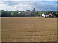
5
Calcutta Pit pumping engine house.
A difficult call for classification but it was used for colliery drainage so colliery it is.
According to the late George Watkins the pumping engine was a horizontal tandem compound rotative by Robert Stephenson & Co., No. 328 of 1877. The cylinders were 42" & 72" bores by 8' stroke. It was 125' long including the two pump bobs that were below the head-gear and over the shaft. The flywheel was a monster at 32' It's a shame that it's gone but the house is excellent. It is now used by Roshal Space Consultants (helping people to make the most of their space - not outer space) and is called "Heritage House".
Image: © Chris Allen
Taken: 2 Feb 2008
0.18 miles
6
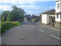
Talbot Lane
Heading north-west along the road to Peggs Green.
Image: © Trevor Rickard
Taken: 29 Aug 2009
0.19 miles
7
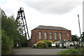
Calcutta Pit pumping engine house
See my previous picture for a description Image
Image: © Chris Allen
Taken: 25 Jul 2009
0.19 miles
8
Calcutta Pit
Pit headgear and engine house.
Image: © Trevor Rickard
Taken: 29 Aug 2009
0.20 miles
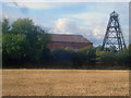
9
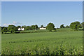
Talbot House Farmhouse and Treborough Cottage
Viewed across fields of wheat from the lane to Calcutta Pit.
Image: © Alan Murray-Rust
Taken: 5 Jun 2014
0.20 miles
10
Rape crop near Thringstone - 2
Looking north down the public footpath to houses at Thringstone. Grace Dieu Wood on the right.
Image: © Trevor Rickard
Taken: 29 Aug 2009
0.20 miles