IMAGES TAKEN NEAR TO
Clay Lane, COALVILLE, LE67 8JE
Introduction
This page details the photographs taken nearby to Clay Lane, LE67 8JE by members of the Geograph project.
The Geograph project started in 2005 with the aim of publishing, organising and preserving representative images for every square kilometre of Great Britain, Ireland and the Isle of Man.

There are currently over 7.5m images from over14,400 individuals and you can help contribute to the project by visiting https://www.geograph.org.uk
Image Map
Images are licensed for reuse under creativecommons.org/licenses/by-sa/2.0
Notes
- Clicking on the map will re-center to the selected point.
- The higher the marker number, the further away the image location is from the centre of the postcode.
Image Listing (9 Images Found)
Images are licensed for reuse under creativecommons.org/licenses/by-sa/2.0
Image
Details
Distance
1
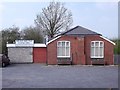
The Beaumont Centre
The Beaumont Social Centre is now the Coleorton parish hall but was originally the Miners' Welfare Institute. Beaumont was the name of one of the local coal owners. The stone plaque below the roof-line reads "WELFARE INSTITUTE".
Image: © Ian Calderwood
Taken: 9 Apr 2015
0.12 miles
2
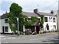
New Inn, Pegg's Green
One of the most friendly pubs we have ever been in, with good beer and very good value food.
Image: © Richard Green
Taken: 24 Jul 2010
0.12 miles
3
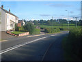
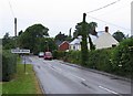
Nottingham Road
Looking south down Nottingham Road at Griffydam. Anchor Lane joining from the left.
Image: © Trevor Rickard
Taken: 29 Aug 2009
0.15 miles
4
Trackbed towards Pegg's Green
The trackbed of the former Swannington and Worthington Rough Railway, now used as a public footpath, looking from the site of Stoney Lane level crossing towards Pegg's Green.
Image: © Richard Green
Taken: 24 Jul 2010
0.16 miles
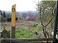
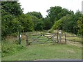
5
Trackbed towards Lount
The trackbed of the Swannington and Worthington Rough Railway, somewhat overgrown since closure in 1872, viewed towards Lount across the site of Stoney Lane level crossing.
Image: © Richard Green
Taken: 24 Jul 2010
0.17 miles
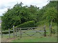
6
Stoney Lane level crossing
The Swannington and Worthington Rough Railway crossed Stoney Lane here. The line was horse operated, opened in 1833 and closed in 1872.
Image: © Richard Green
Taken: 24 Jul 2010
0.18 miles
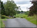
7
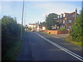
Houses at Griffydam
Looking north along Nottingham Road.
Image: © Trevor Rickard
Taken: 29 Aug 2009
0.19 miles