IMAGES TAKEN NEAR TO
Bardon Hill, COALVILLE, LE67 1TG
Introduction
This page details the photographs taken nearby to LE67 1TG by members of the Geograph project.
The Geograph project started in 2005 with the aim of publishing, organising and preserving representative images for every square kilometre of Great Britain, Ireland and the Isle of Man.

There are currently over 7.5m images from over14,400 individuals and you can help contribute to the project by visiting https://www.geograph.org.uk
Image Map
Images are licensed for reuse under creativecommons.org/licenses/by-sa/2.0
Notes
- Clicking on the map will re-center to the selected point.
- The higher the marker number, the further away the image location is from the centre of the postcode.
Image Listing (7 Images Found)
Images are licensed for reuse under creativecommons.org/licenses/by-sa/2.0
Image
Details
Distance
3
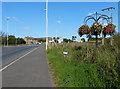
East Lane
Looking north-west along East Lane, which appropriately flanks the east side of the Bardon industrial estate.
Image: © Trevor Rickard
Taken: 6 Nov 2010
0.18 miles
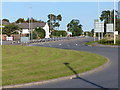
5
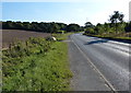
Heading south along the B585 West Lane
Image: © Mat Fascione
Taken: 29 Sep 2013
0.24 miles
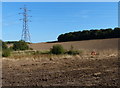
6
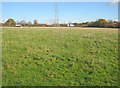
Grazing land near the A511
Looking north-east along the power lines to the busy main road at the far end of the field. Much scaffolding in place either side of the road as these lines are being replaced - see Image
Image: © Trevor Rickard
Taken: 6 Nov 2010
0.24 miles
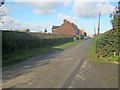
7
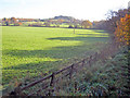
Meadows south of the A511
From the old railway embankment looking east towards Billa Barra Hill.
Image: © Trevor Rickard
Taken: 6 Nov 2010
0.24 miles