IMAGES TAKEN NEAR TO
Oakleigh Court, Derby Road, ASHBY-DE-LA-ZOUCH, LE65 2UD
Introduction
This page details the photographs taken nearby to Oakleigh Court, Derby Road, LE65 2UD by members of the Geograph project.
The Geograph project started in 2005 with the aim of publishing, organising and preserving representative images for every square kilometre of Great Britain, Ireland and the Isle of Man.

There are currently over 7.5m images from over14,400 individuals and you can help contribute to the project by visiting https://www.geograph.org.uk
Image Map (Loading...)


Getting Data...Please wait
Leaflet Map data © OpenStreetMap
Images are licensed for reuse under creativecommons.org/licenses/by-sa/2.0
Notes
- Clicking on the map will re-center to the selected point.
- The higher the marker number, the further away the image location is from the centre of the postcode.
Image Listing (300 Images Found)
Images are licensed for reuse under creativecommons.org/licenses/by-sa/2.0
Image
Details
Distance
1
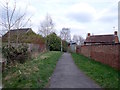
Former tramway footpath
This short length of path is on the route of the 1802 Ashby Railway, a.k.a. Ticknall Tramway. When its replacement, the Ashby and Breedon railway, was built over parts of the route, many old sections were left disused. However, this section, although no longer part of the through-route, was retained as a siding.
Image: © Ian Calderwood
Taken: 3 Apr 2016
0.03 miles
2
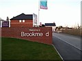
Entrance to the Brookmead estate, Ashby
The 'Brookme d' estate was recently built, in replacement to the old soap factory, in Ashby de-la Zouch.
Image: © Oliver Mills
Taken: 25 Sep 2015
0.04 miles
3
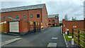
"Holywell Mill", Ashby-de-la-Zouch
The entrance to the new housing estate on the site of the destroyed Holywell Mill, now a gated community.
Image: © Oliver Mills
Taken: 17 Jan 2021
0.05 miles
4
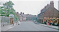
Entering Ashby-de-la-Zouch on Burton Road, 1962
View east, past the Ashby Primary School, on what was the A50 trunk road from Burton-on-Trent until about 1990, when new roads and by-passes round Ashby and Coalville were built.
Image: © Ben Brooksbank
Taken: 4 Jun 1962
0.05 miles
5
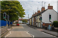
Burton Road, Ashby De La Zouch
Looking towards the roundabout which connects Derby Road and Elford Street (turning into North Street). The C of E primary school is on the left, and the Methodist church on the right.
This picture can be compared with another picture taken in 1962, which can be seen here Image As is the case with many places, things generally look less idyllic today than it did 50 years ago.
Image: © Oliver Mills
Taken: 8 Oct 2017
0.05 miles
6
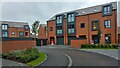
Holywell Mill housing estate, Ashby-de-la-Zouch
Various houses of different forms in the new housing estate, on the site of the destroyed Holywell Mill. The estate is only partially inhabited and will be a gated community.
Image: © Oliver Mills
Taken: 17 Jan 2021
0.06 miles
7
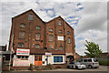
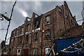
Holywell Mill, Ashby
A prominent landmark in Ashby, located near the C of E school on Burton Road. Despite universal local opposition, this building is to be demolished, and replaced with... housing.
UPDATE!! Holywell Mill was destroyed by fire on the night of 13/02/2018.
Image
Image
Image: © Oliver Mills
Taken: 11 Jun 2017
0.06 miles
8
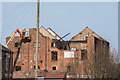
Holywell Mill, Ashby, following the fire
A view of the ruined Holywell Mill, following the devastating fire several nights before. The building is now a fire-damaged shell, and the two southern gables have now collapsed, due to the loss of support from the roof. The remains will be demolished quickly.
Image: © Oliver Mills
Taken: 16 Feb 2018
0.06 miles
9
The ruins of Holywell Mill
The remains of the mill are slowly being demolished, after the building was destroyed by fire in February. The cause of the fire was arson.
Image: © Oliver Mills
Taken: 10 Mar 2018
0.06 miles
10
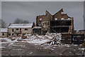
The ruins of Holywell Mill
The remains of the fire-damaged mill are slowly being demolished. The focus of the fire can be clearly seen, due to the blackened walls.
Image: © Oliver Mills
Taken: 18 Mar 2018
0.06 miles