IMAGES TAKEN NEAR TO
Woodside, ASHBY-DE-LA-ZOUCH, LE65 2NJ
Introduction
This page details the photographs taken nearby to Woodside, LE65 2NJ by members of the Geograph project.
The Geograph project started in 2005 with the aim of publishing, organising and preserving representative images for every square kilometre of Great Britain, Ireland and the Isle of Man.

There are currently over 7.5m images from over14,400 individuals and you can help contribute to the project by visiting https://www.geograph.org.uk
Image Map
Images are licensed for reuse under creativecommons.org/licenses/by-sa/2.0
Notes
- Clicking on the map will re-center to the selected point.
- The higher the marker number, the further away the image location is from the centre of the postcode.
Image Listing (6 Images Found)
Images are licensed for reuse under creativecommons.org/licenses/by-sa/2.0
Image
Details
Distance
1

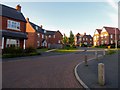
Ash Tree Fields under construction
Ash Tree Fields is a new development of four-bedroomed houses by Bloor Homes
Image: © Ian Calderwood
Taken: 20 Oct 2015
0.07 miles
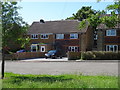
2
Philip Bent Road, Ashby-de-la-Zouch
A relatively new housing estate, completed in about 2015. A public footpath running through the previously undeveloped field is now re-routed through the estate.
Image: © Oliver Mills
Taken: 5 May 2020
0.08 miles
3
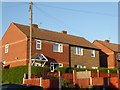
A prefabricated house in Ashby-de-la-Zouch
Probably of the 'Airey' type. The estate was built shortly after WWII; the majority of houses have since been modernised with retrofitted brick skins over the original structure.
Image: © Oliver Mills
Taken: 6 May 2020
0.17 miles
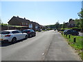
6
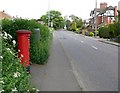
Postbox along Moira Road in Ashby de la Zouch
Image: © Mat Fascione
Taken: 18 May 2008
0.23 miles