IMAGES TAKEN NEAR TO
Normanton Road, ASHBY-DE-LA-ZOUCH, LE65 1WS
Introduction
This page details the photographs taken nearby to Normanton Road, LE65 1WS by members of the Geograph project.
The Geograph project started in 2005 with the aim of publishing, organising and preserving representative images for every square kilometre of Great Britain, Ireland and the Isle of Man.

There are currently over 7.5m images from over14,400 individuals and you can help contribute to the project by visiting https://www.geograph.org.uk
Image Map
Images are licensed for reuse under creativecommons.org/licenses/by-sa/2.0
Notes
- Clicking on the map will re-center to the selected point.
- The higher the marker number, the further away the image location is from the centre of the postcode.
Image Listing (61 Images Found)
Images are licensed for reuse under creativecommons.org/licenses/by-sa/2.0
Image
Details
Distance
1

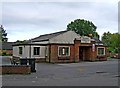
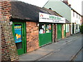
Normanton Road and the "Mcmansion", Packington
A recently built property which could be perceived as a "Mcmansion". This term originates in America; gladly "Mcmansions" are hard to come by in the UK.
Image: © Oliver Mills
Taken: 13 Jan 2022
0.05 miles
2
Packington Memorial Hall, High Street
This village hall was built in 1957. In 2009 sufficient money was raised to enable the hall to be renovated and modernised. The work should be completed by December 2009.
Image: © P L Chadwick
Taken: 22 May 2009
0.08 miles
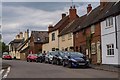
3
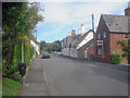
High Street - 1
Looking north with a large thatched cottage on the right.
Image: © Trevor Rickard
Taken: 29 Aug 2009
0.08 miles
4
Packington Methodist Church, High Street
Next to Packington Memorial Hall, and opposite Hall Lane, is Packington Methodist Church. The church was constructed in 1905 of limestone.
Image: © P L Chadwick
Taken: 22 May 2009
0.09 miles
5
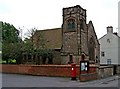
Packington Methodist Church (front view), High Street
The attractive Methodist church dating from 1905, seen from Hall Lane opposite. For another view: Image
Image: © P L Chadwick
Taken: 22 May 2009
0.09 miles
6
Tardis
This little shop in Packington is misleading at first, when you walk in it goes back for what seems like miles, a modern day Arkwright's.
Image: © cris sloan
Taken: 29 Apr 2007
0.09 miles
7
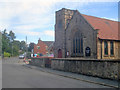
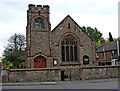
Packington Methodist Church
Looking north along High Street in the centre of the village. Formerly the Wesleyan Methodist Church, it was built in 1905 with local Breedon Limestone.
Image: © Trevor Rickard
Taken: 29 Aug 2009
0.10 miles
8

High Street, Packington
The central section of the street is dominated by this terraced row of houses; further South is the Bull and Lion public house and several more modern housing developments. To the North is the former Methodist Church (closed c.2011), the Memorial Hall and the Daybreak Services shop.
Taken shortly before sunset, with the combination of golden sunlight and cool, deep shadows making white balance selection very challenging!
Image: © Oliver Mills
Taken: 13 Jan 2022
0.10 miles
10
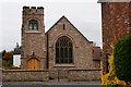
Packington Methodist Church
A view of the former church in the centre of Packington, Leicestershire.
Image: © Oliver Mills
Taken: 23 Oct 2015
0.11 miles