IMAGES TAKEN NEAR TO
Melbourne Road, ASHBY-DE-LA-ZOUCH, LE65 1RU
Introduction
This page details the photographs taken nearby to Melbourne Road, LE65 1RU by members of the Geograph project.
The Geograph project started in 2005 with the aim of publishing, organising and preserving representative images for every square kilometre of Great Britain, Ireland and the Isle of Man.

There are currently over 7.5m images from over14,400 individuals and you can help contribute to the project by visiting https://www.geograph.org.uk
Image Map
Images are licensed for reuse under creativecommons.org/licenses/by-sa/2.0
Notes
- Clicking on the map will re-center to the selected point.
- The higher the marker number, the further away the image location is from the centre of the postcode.
Image Listing (96 Images Found)
Images are licensed for reuse under creativecommons.org/licenses/by-sa/2.0
Image
Details
Distance
1
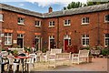
Ferrers Centre, Staunton Harold
A crafts centre in the former stable courtyard of Staunton Harold Hall.
Image: © Oliver Mills
Taken: 10 Jul 2020
0.01 miles
2
Ferrers Centre, Staunton Harold
The arts and crafts complex, in the former stable blocks at the Staunton Harold estate.
Image: © Oliver Mills
Taken: 19 Nov 2016
0.01 miles
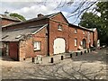
3
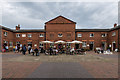
Staunton Harold Stables
A stable block from a historic estate, redeveloped into shops. These include an art gallery, toy shop, cafe and an animatronic 'faerie' workshop.
Image: © Oliver Mills
Taken: 22 Apr 2018
0.01 miles
4
Ferrers Centre at Staunton Harold Hall, Leics
Image: © Colin Park
Taken: 19 Sep 2019
0.01 miles
5
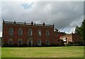
Staunton Harold Hall
View taken southwest.
Image: © sheral wood
Taken: 12 Aug 2007
0.01 miles
6
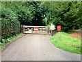
Gate on the Path to Staunton Harold Church
Staunton Harold is a small hamlet originally built by the Shirley Family, Earls Ferrers. It lies in the heart of The National Forest, about 3 miles north of Ashby-de-la-Zouch in Leicestershire. It is on the county boundary with Derbyshire and about 9 miles south of Derby. The 2011 Census recorded the population of Staunton Harold as 141 (http://goo.gl/NaCk5G Office for National Statistics).
Image: © David Dixon
Taken: 15 Sep 2015
0.02 miles
7
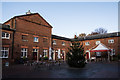
The Ferrers Centre, Staunton Harold
The former stable block of Staunton Harold Hall now hosts a variety of craft shops, studios, and a café.
Image: © David Robinson
Taken: 13 May 2022
0.03 miles
8
Staunton Harold, The Ferrers Centre
Staunton Harold Hall’s late-eighteenth century stable block is occupied by a number of small craft enterprises as the Ferrers Centre for Arts and Crafts http://www.ferrerscentre.co.uk/ . It is a grade II listed building (English Heritage Building ID: 187843 http://www.britishlistedbuildings.co.uk/en-187843-stable-block-staunton-harold-leicestersh#.Vf6OGHmFOHs British Listed Buildings).
Image: © David Dixon
Taken: 15 Sep 2015
0.03 miles
9
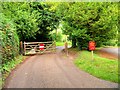
Gate on Staunton Harold Estate
Staunton Harold is a small hamlet originally built by the Shirley Family, Earls Ferrers. It lies in the heart of The National Forest, about 3 miles north of Ashby-de-la-Zouch in Leicestershire. It is on the county boundary with Derbyshire and about 9 miles south of Derby. The 2011 Census recorded the population of Staunton Harold as 141 (http://goo.gl/NaCk5G Office for National Statistics).
Image: © David Dixon
Taken: 15 Sep 2015
0.03 miles
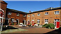
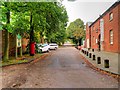
10
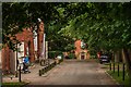
Road to Staunton Harold Hall
The Ferrers Centre on the left, Staunton Harold Hall and Church straight ahead.
Image: © Oliver Mills
Taken: 10 Jul 2020
0.03 miles