IMAGES TAKEN NEAR TO
Money Hill, ASHBY-DE-LA-ZOUCH, LE65 1JH
Introduction
This page details the photographs taken nearby to Money Hill, LE65 1JH by members of the Geograph project.
The Geograph project started in 2005 with the aim of publishing, organising and preserving representative images for every square kilometre of Great Britain, Ireland and the Isle of Man.

There are currently over 7.5m images from over14,400 individuals and you can help contribute to the project by visiting https://www.geograph.org.uk
Image Map
Images are licensed for reuse under creativecommons.org/licenses/by-sa/2.0
Notes
- Clicking on the map will re-center to the selected point.
- The higher the marker number, the further away the image location is from the centre of the postcode.
Image Listing (7 Images Found)
Images are licensed for reuse under creativecommons.org/licenses/by-sa/2.0
Image
Details
Distance
1
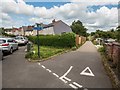
Footpaths off Northfields, Ashby-de-la-Zouch
An early 20th Century housing estate, positioned at an angle from the connecting Smisby Road to give way for the now-demolished railway. Down the lane to the right, turning right gives access to a cycle route into Ashby, and turning left leads along a footpath towards Cliftonthorpe. The farm track ahead is private, leading to Money Hill Farm.
Image: © Oliver Mills
Taken: 6 Jul 2020
0.12 miles
2
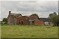
Money Hill Farm, Ashby
A series of derelict farm buildings on the outskirts of Ashby-de-la-Zouch.
Image: © Oliver Mills
Taken: 29 Jul 2017
0.13 miles
3
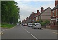
Smisby Road in Ashby de la Zouch, Leicestershire
Image: © Mat Fascione
Taken: 18 May 2008
0.14 miles
4
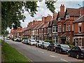
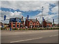
Smisby Road, Ashby-de-la-Zouch
Containing primarily Victorian terraced houses, with c.1920s houses on the left side of the road.
Image: © Oliver Mills
Taken: 6 Jul 2020
0.15 miles
5
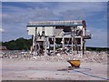
Demolition at Arla
Arla Foods closed its dairy and distribution centre in 2014 after transferring production to its new processing facility in Aylesbury, Buckinghamshire.
Image: © Ian Calderwood
Taken: 2 Aug 2015
0.18 miles
6
Potter's Grange, Smisby Road, Ashby-de-la-Zouch
An under-construction housing estate, on the site of an Arla dairy.
Image: © Oliver Mills
Taken: 6 Jul 2020
0.19 miles
7
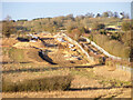
Road construction at the "Money Hill Development", Ashby-de-la-Zouch
A new housing development will cover the majority of the open space bound by Smisby Road, Nottingham Road and the A511 Ashby Bypass. The alignment of the road construction shown in this view appears to be the same as an existing private farm track which runs from 55 Wood Street into roughly the centre of this development plot. As is obscurely evident in this photograph, the works eventually bend to the right and approach the newly-completed roundabout on the A511.
Image: © Oliver Mills
Taken: 5 Feb 2023
0.22 miles