IMAGES TAKEN NEAR TO
Dunbar Way, ASHBY-DE-LA-ZOUCH, LE65 1AQ
Introduction
This page details the photographs taken nearby to Dunbar Way, LE65 1AQ by members of the Geograph project.
The Geograph project started in 2005 with the aim of publishing, organising and preserving representative images for every square kilometre of Great Britain, Ireland and the Isle of Man.

There are currently over 7.5m images from over14,400 individuals and you can help contribute to the project by visiting https://www.geograph.org.uk
Image Map
Images are licensed for reuse under creativecommons.org/licenses/by-sa/2.0
Notes
- Clicking on the map will re-center to the selected point.
- The higher the marker number, the further away the image location is from the centre of the postcode.
Image Listing (34 Images Found)
Images are licensed for reuse under creativecommons.org/licenses/by-sa/2.0
Image
Details
Distance
1
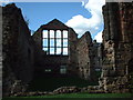
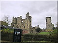
Ashby de la Zouche Castle
On the Western side of the square
Image: © Chris Shaw
Taken: Unknown
0.01 miles
2
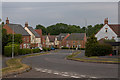
Abbotsford Road, Ashby-de-la-Zouch
A relatively recent housing estate; a major expansion on a previous development.
Image: © Oliver Mills
Taken: 8 Jun 2020
0.07 miles
3
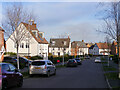
Hastings Park, Ashby-de-la-Zouch
A view along Dunbar Way, the main road through this housing development. Many of the houses along this road are generously finished in white render - to good effect. The development was largely completed by David Wilson Homes in around 2015.
Image: © Oliver Mills
Taken: 5 Feb 2023
0.12 miles
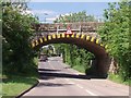
5
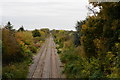
Leicester to Burton railway from Ashby de la Zouch - Eastern view
A view of the railway that passes through Ashby de la Zouch. The railway crosses the A42, just past the red light to the left of the railway.
Image: © Oliver Mills
Taken: 23 Oct 2015
0.17 miles
7
Ashby de-la-Zouch castle
View from the top of the tower.
Image: © Malcolm Neal
Taken: 2 Aug 2024
0.18 miles
8
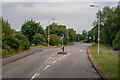
Leicester Road, Ashby-de-la-Zouch
Looking Southwards, where the road eventually passes through New Packington. The road entrances on both sides provide access to small housing estates.
Image: © Oliver Mills
Taken: 8 Jun 2020
0.18 miles
9
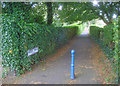
Mount Walk
Heading north from the junction of Prior Park Road and Upper Packington Road, this walkway provides a direct pedestrian route to the town centre.
Image: © Trevor Rickard
Taken: 29 Aug 2009
0.18 miles
10
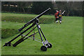
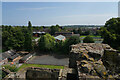
Ashby Castle
The castle at Ashby de la Zouch is the place where many activities of the Sealed Knot Society take place. You can see some of the weapons that are used during their re-enactments.
Image: © Malcolm Neal
Taken: 28 Mar 2005
0.19 miles