IMAGES TAKEN NEAR TO
Mayflower Road, LEICESTER, LE5 5QE
Introduction
This page details the photographs taken nearby to Mayflower Road, LE5 5QE by members of the Geograph project.
The Geograph project started in 2005 with the aim of publishing, organising and preserving representative images for every square kilometre of Great Britain, Ireland and the Isle of Man.

There are currently over 7.5m images from over14,400 individuals and you can help contribute to the project by visiting https://www.geograph.org.uk
Image Map
Images are licensed for reuse under creativecommons.org/licenses/by-sa/2.0
Notes
- Clicking on the map will re-center to the selected point.
- The higher the marker number, the further away the image location is from the centre of the postcode.
Image Listing (20 Images Found)
Images are licensed for reuse under creativecommons.org/licenses/by-sa/2.0
Image
Details
Distance
1
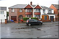
Nos.52 and 54 Evington Lane
Ordnance Survey documents indicate that in 1965 a benchmark levelled at 78.343m above Newlyn Datum was verified on a garage attached to the rear side of the left hand house. It is evident that a new integral garage with rooms above has replaced the original garage.
Image: © Roger Templeman
Taken: 18 Sep 2017
0.12 miles
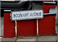
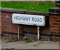
2
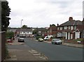
North end of Highway Road
The road on the left is Bodnant Avenue and Evington Lane crosses the end of Highway Road.
Image: © Andrew Tatlow
Taken: 8 Sep 2011
0.13 miles
3
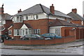
No. 44 Evington Lane at junction with Norwood Road
There is an Ordnance Survey benchmark Image on the near corner of the house, right hand face, on the approach to the attached garage.
Image: © phil Richards
Taken: 9 Sep 2017
0.14 miles
4
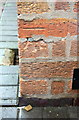
Benchmark on No. 44 Evington Lane
Ordnance Survey cut mark benchmark described on the Bench Mark Database at www.bench-marks.org.uk/bm88700
Image: © phil Richards
Taken: 9 Sep 2017
0.14 miles
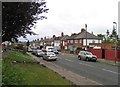
5
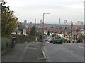
Horston Hill, Leicester
Looking westwards down Evington Lane towards the city centre.
Image: © Kate Jewell
Taken: 21 Dec 2005
0.14 miles
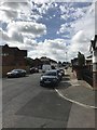
6
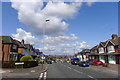
Evington Lane
Cycle Route 63 turns off this busy road, down Coplow Avenue to the left
Image: © Tim Heaton
Taken: 13 Aug 2019
0.15 miles